London Britain Township, Pennsylvania
| London Britain Township | |
| Township | |
|
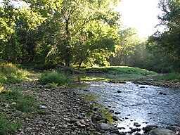
White Clay Creek Preserve is a PA state park in London Britain Township
|
|
| Country | United States |
|---|---|
| State | Pennsylvania |
| County | Chester |
| Elevation | 138 ft (42.1 m) |
| Coordinates | 39°45′09″N 75°46′48″W / 39.75250°N 75.78000°WCoordinates: 39°45′09″N 75°46′48″W / 39.75250°N 75.78000°W |
| Area | 9.9 sq mi (25.6 km2) |
| - land | 9.9 sq mi (26 km2) |
| - water | 0.0 sq mi (0 km2), 0% |
| Population | 3,139 (2010) |
| Density | 317.1/sq mi (122.4/km2) |
| Timezone | EST (UTC-5) |
| - summer (DST) | EDT (UTC-4) |
| Area code | 610 484 |
|
Location in Chester County and the state of Pennsylvania.
|
|
|
Location of Pennsylvania in the United States
|
|
|
Website: www |
|
London Britain Township is a township in Chester County, Pennsylvania, United States. The population was 3,139 at the 2010 census. White Clay Creek Preserve is a Pennsylvania state park in London Britain Township along White Clay Creek.
On March 14, 1681, William Penn received a charter from the King of England for a grant of land to establish a colony in the New World. This colony was named Pennsylvania, or Penn's Woods. The Township of London Britain was organized in 1725 from a tract of land belonging to the London Company of Great Britain. The southernmost part of the township was originally disputed territory between Pennsylvania and Maryland, resolved eventually by the Mason–Dixon line. The southernmost section of the township formed the northern section of New Munster, a large settlement tract established by Maryland and named after the southern province of Munster in Ireland. New Munster acted as an early genesis point and catalyst for large Scotch-Irish settlement and expansion into Chester County and points west in Pennsylvania.
Lunn's Tavern and the Thompson Farm are listed on the National Register of Historic Places.
According to the United States Census Bureau, the township has a total area of 9.9 square miles (26 km2), all of it land. London Britain is bordered by Maryland on the south and Delaware on the east. The Mason–Dixon Line marks the border between the township and Maryland. The White Clay Creek Preserve makes up 1,255 acres (508 ha) of the township. The White Clay Creek watershed was designated as a National Wild and Scenic River on October 24, 2000.
...
Wikipedia


