Loenen (Apeldoorn)
| Loenen | |
|---|---|
| Village | |
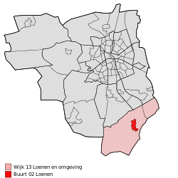
 Location of Loenen in the municipality of Apeldoorn (the urban area of Beekbergen is red and the rural area is pink) |
|
| Location of Loenen in Gelderland | |
| Coordinates: 52°6′59″N 6°1′8″E / 52.11639°N 6.01889°E | |
| Country | Netherlands |
| Province | Gelderland |
| Municipality | Apeldoorn |
| Area | |
| • Village | 36.9 km2 (14.2 sq mi) |
| • Urban | 1.2 km2 (0.5 sq mi) |
| Elevation | 25 m (82 ft) |
| Population (January 1, 2015) | |
| • Village | 3,066 |
| • Density | 83/km2 (220/sq mi) |
| • Urban | 2,116 |
| Time zone | CET (UTC+1) |
| • Summer (DST) | CEST (UTC+2) |
| Postcodes | 7370 and 7371 |
| Area code | 055 |
Loenen is a village in the Dutch province of Gelderland. It is located in the municipality of Apeldoorn, about 10 km southeast of that city.
Loenen was a separate municipality until 1818, when it was merged with Apeldoorn.
Coordinates: 52°07′00″N 6°01′12″E / 52.11667°N 6.02000°E
...
Wikipedia

