Lochsa River
| Lochsa River | |
|
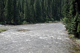
Headwaters near Powell
|
|
| Name origin: Nez Perce word for "rough water" | |
| Country | United States |
|---|---|
| State | Idaho |
| County | Idaho |
| Source | Confluence of Crooked Fork and Colt Killed Creek, Bitterroot Mountains |
| - location | Near Powell Ranger Station, Idaho County, Idaho |
| - elevation | 3,441 ft (1,049 m) |
| - coordinates | 46°30′30″N 114°40′54″W / 46.50833°N 114.68167°W |
| Mouth | Clearwater River |
| - location | Lowell, Idaho County, Idaho |
| - elevation | 1,453 ft (443 m) |
| - coordinates | 46°08′25″N 115°35′58″W / 46.14028°N 115.59944°WCoordinates: 46°08′25″N 115°35′58″W / 46.14028°N 115.59944°W |
| Length | 70.1 mi (113 km) |
| Basin | 1,180 sq mi (3,056 km2) |
| Discharge | for Lowell, 0.9 miles (1.4 km) from mouth |
| - average | 2,822 cu ft/s (80 m3/s) |
| - max | 35,100 cu ft/s (994 m3/s) |
| - min | 100 cu ft/s (3 m3/s) |
|
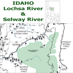
Lochsa and Selway rivers
|
|
The Lochsa River is in the northwestern United States, in the mountains of north central Idaho. It is one of two primary tributaries (with the Selway to the south) of the Middle Fork of the Clearwater River in the Clearwater National Forest. Lochsa is a Nez Perce word meaning rough water. The Salish name is Ep Smɫí, "It Has Salmon."
The Lochsa (pronounced "lock-saw") was included by the U.S. Congress in 1968 as part of the National Wild and Scenic Rivers Act. The Lochsa and Selway rivers and their tributaries have no dams, and their flow is unregulated. In late spring, mid-May to mid-June, the Lochsa River is rated as one of the world's best for continuous whitewater.
The main stem of the Lochsa is 70 miles (113 km) long from its headwaters near Powell Ranger Station in the Bitterroots to Lowell, Idaho, where the Lochsa joins the Selway River to form the Middle Fork of the Clearwater. Over this distance, the river drops nearly 2,000 feet (610 m) from 3,441 feet (1,049 m) above sea level at Powell to 1,453 feet (443 m) at Lowell.
The drainage basin for the Lochsa River system covers 1,180 square miles (3,056 km2) in Idaho County. The river is fed by the melting of the significant snowpack of the Bitterroot Range.
The Lochsa River begins at the confluence of Crooked Fork and Colt Killed Creek (also called White Sand Creek) near the Powell Ranger Station in northeastern Idaho and flows 70.1 miles (112.8 km) southwest to the small town of Lowell. Running parallel to U.S. Route 12 for its entire length, the river winds through the Clearwater National Forest in the Bitterroot Mountains. Just below Lowell, the Lochsa and the Selway River join to form the Middle Fork Clearwater River.
...
Wikipedia


