Bitterroot Range
| Bitterroot Range | |
|---|---|

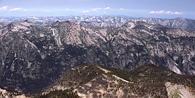
Part of the Bitterroot Range in Montana, looking north from El Capitan peak
|
|
| Highest point | |
| Peak | Scott Peak |
| Elevation | 11,393 ft (3,473 m) |
| Coordinates | 44°21′14″N 112°49′17″W / 44.353807°N 112.821407°WCoordinates: 44°21′14″N 112°49′17″W / 44.353807°N 112.821407°W |
| Dimensions | |
| Length | 304 mi (489 km) N/S |
| Width | 268 mi (431 km) E/W |
| Area | 14,742 sq mi (38,180 km2) |
| Geography | |
| Country | United States |
| States | Idaho and Montana |
| Parent range | Rocky Mountains |
The Bitterroot Range is a mountain range and a subrange of the Rocky Mountains that runs along the border of Montana and Idaho in the northwestern United States. The range spans an area of 24,223 square miles (62,740 km2) and is named after the bitterroot (Lewisia rediviva), a small pink flower that is the state flower of Montana.
In 1805, the Corps of Discovery, led by Meriwether Lewis and William Clark and aided by Sacajawea of the Shoshone Native American tribe, crossed the Bitterroot Range several times. Lewis first crossed the mountains at Lemhi Pass on August 12, then returned across the pass to meet Clark. The entire expedition then crossed the pass to the Salmon River valley, and the next month entered the Bitterroot Valley from the south via either Lost Trail Pass or Chief Joseph Pass. It then crossed Lolo Pass to the west. The mountains were crossed by the Chicago, Milwaukee, St. Paul and Pacific Railroad (the "Milwaukee Road").
According to the U.S. Board on Geographic Names, the Bitterroot Range runs from Pend Oreille Lake (near Sandpoint, Idaho) to Monida Pass,. It is sometimes considered to extend east of the Monida Pass to include the Centennial Mountains. The range comprises the following subranges (from north to south):
...
Wikipedia
