Lolo Pass (Idaho-Montana)
| Lolo Pass | |
|---|---|

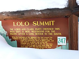
Historical marker sign in Idaho in 2011
|
|
| Elevation | 5,233 ft (1,595 m) |
| Traversed by |
|
| Location |
Idaho Co., Idaho, & Missoula Co., Montana, United States |
| Range |
Bitterroot Range, Rocky Mountains |
| Coordinates | 46°38′06″N 114°34′48″W / 46.635°N 114.580°W |
|
Lolo Trail
|
|
| Location |
Bitterroot Mountains, Idaho-Montana |
|---|---|
| Coordinates | 46°38′06″N 114°34′48″W / 46.635°N 114.580°WCoordinates: 46°38′06″N 114°34′48″W / 46.635°N 114.580°W |
| Built | 1805 |
| NRHP Reference # | 66000309 |
| Added to NRHP | October 15, 1966 |
Lolo Pass, elevation 5,233 feet (1,595 m), is a mountain pass in the western United States, in the Bitterroot Range of the northern Rocky Mountains. It is on the border between the states of Montana and Idaho, approximately 40 miles (65 km) west-southwest of Missoula, Montana.
The pass is the highest point of the historic Lolo Trail, between the Bitterroot Valley in Montana and the Weippe Prairie in Idaho. The trail, known as naptnišaqs, or "Nez Perce Trail" in Salish, was used by Nez Perce in the 18th century, and by the Lewis and Clark Expedition, guided by Old Toby of the Shoshone, on their westward snowbound journey in September 1805. After a winter at Fort Clatsop in present-day northwestern Oregon, the Corps of Discovery returned the following June. The Lolo Trail is a National Historic Landmark, designated for its importance to the Lewis and Clark Expedition, and its role in the 1877 Nez Perce War.
The name of the pass is sometimes said to have been Salish version of the French name Laurence or Laurent, but was probably a regular French nickname. The name Lolo was not used by Lewis and Clark. Its first known mention is in the 1810 journal of David Thompson, who described three fur trappers, probably of French descent, named Michael, Lolo, and Gregoire.
...
Wikipedia

