Llawhaden
| Llawhaden | |
|---|---|
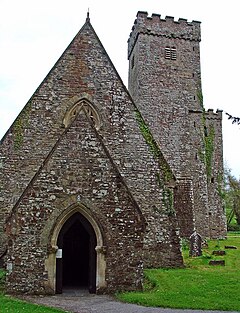
 St Aidan's church |
|
| Llawhaden shown within Pembrokeshire | |
| Population | 688 (2011) |
| OS grid reference | SN072175 |
| Principal area | |
| Country | Wales |
| Sovereign state | United Kingdom |
| Post town | Narberth |
| Postcode district | SA67 8 |
| Dialling code | 01437 |
| Police | Dyfed-Powys |
| Fire | Mid and West Wales |
| Ambulance | Welsh |
| EU Parliament | Wales |
| UK Parliament | |
| Welsh Assembly | |
Llawhaden (Welsh: Llanhuadain) is a village and community in the Hundred of Dungleddy (Welsh: Daugleddyf), Pembrokeshire, West Wales. The community of Llawhaden includes the parish of Robeston Wathen, part of Narberth and the hamlet of Gelli, and had a population of 634 in 2001, increasing to 688 at the 2011 Census.
The name Llawhaden is an anglicised version of the Welsh form Llanhuadain, and probably means "(monastic) enclosure of St Aidan".
The village is in the form of a large medieval planned settlement, although most of the land lots laid out along the main street are now vacant. At the end of the main street, spectacularly overlooking the Cleddau valley, is a substantial castle, Llawhaden Castle. The parish church of St Aidan (of Ferns, a disciple of Saint David) is situated below the village beside the river, at 51°49′21″N 4°47′40″W / 51.8226°N 4.7944°W.
...
Wikipedia

