Llanfihangel Penbedw
| Llanfihangel Penbedw | |
|---|---|
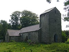
 St Michael's Church, 2007 |
|
| Llanfihangel Penbedw shown within Pembrokeshire | |
| OS grid reference | SN2039 |
| Community | |
| Principal area | |
| Country | Wales |
| Sovereign state | United Kingdom |
| Post town | Boncath |
| Postcode district | SA |
| Dialling code | 01239 |
| Police | Dyfed-Powys |
| Fire | Mid and West Wales |
| Ambulance | Welsh |
| EU Parliament | Wales |
| UK Parliament | |
| Welsh Assembly | |
Llanfihangel Penbedw is a parish in the former Hundred of Kilgerran in northeast Pembrokeshire, Wales. The parish, a joint curacy with Capel Colman, in the Diocese of St David's in the Church in Wales, included the village of Boncath and part of the village of Blaenffos. The parish church is abandoned and the civil parish has been absorbed into Boncath Community.
Llanfihangel refers to St Michael the Archangel, to whom the parish church is dedicated. Penbedw refers to a headland of birch trees, which relates to the similarly named Birkenhead on Merseyside. Penbedw has also been translated as birch-covered hill.
The earliest recorded date of the parish is 1325, with the patronage before that date belonging to the Earl of Pembroke.
The living of the parish was presented to George Owen Harry (or Henry) in 1594 by George Owen, Lord of Cemais. Harry held the living until his death in 1614.Richard Fenton the Welsh topographer and poet in his 1811 work A Historical Tour through Pembrokeshire made liberal use of Harry's manuscripts.
Parish records exist from the 17th century to 1970, with the last recorded burial in 1916. The church was rebuilt on the old foundations in the 19th century.
Throughout the 19th century the population of the parish remained relatively constant at between 200 and 350. In 1833 the parish had 353 inhabitants and was under the patronage of the Crown with the 1,000 acres (400 ha) valued at £70 10s. Falling under Cardigan Union, the Poor Law Commissioners reported that an average of £88 was expended on the poor of the parish between 1834 to 1836. Tithe maps and archives of 1840 are held at the National Archives.
The land in the parish was described as "good Sporting Country and surrounded by well-preserved Estates" in a notice of 1869 where over 1,000 acres (400 ha) of arable, grass and woodland across five parishes was for sale freehold. The parish area was 2,410 acres (980 ha) in the 1870s and had a population of 287. In 1881 the majority of males in the parish were working in agriculture.
...
Wikipedia

