Llançà
| Llançà | |||
|---|---|---|---|
| Municipality | |||
 |
|||
|
|||
| Location in Catalonia | |||
| Coordinates: 42°22′10″N 3°09′40″E / 42.36944°N 3.16111°ECoordinates: 42°22′10″N 3°09′40″E / 42.36944°N 3.16111°E | |||
| Country |
|
||
| Community |
|
||
| Province | Girona | ||
| Comarca | Alt Empordà | ||
| Government | |||
| • Mayor | Guillem Cusí Batlle (2015) | ||
| Area | |||
| • Total | 28.0 km2 (10.8 sq mi) | ||
| Elevation | 4 m (13 ft) | ||
| Population (2014) | |||
| • Total | 4,970 | ||
| • Density | 180/km2 (460/sq mi) | ||
| Demonym(s) | Llançanenc, llançanenca | ||
| Website | www |
||
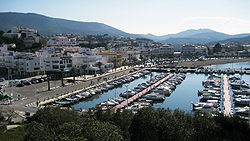
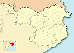
Llançà (Catalan pronunciation: [ʎənˈsa]) is a municipality in the comarca of the Alt Empordà in Catalonia, Spain. It is situated on the coastline of the Costa Brava, between the Cap de Creus and the French frontier and is an important fishing port and tourist centre. The C-252 connects the town with Figueres and continues on to the border at Portbou.
...
Wikipedia


