Livry Gargan
| Livry-Gargan | ||
|---|---|---|

Livry-Gargan town hall
|
||
|
||
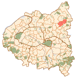
 Paris and inner ring departments |
||
| Coordinates: 48°55′09″N 2°32′10″E / 48.9192°N 2.5361°ECoordinates: 48°55′09″N 2°32′10″E / 48.9192°N 2.5361°E | ||
| Country | France | |
| Region | Île-de-France | |
| Department | Seine-Saint-Denis | |
| Arrondissement | Le Raincy | |
| Canton | Livry-Gargan | |
| Government | ||
| • Mayor (2014–2020) | Pierre-Yves Martin | |
| Area1 | 7.38 km2 (2.85 sq mi) | |
| Population (2006)2 | 42,075 | |
| • Density | 5,700/km2 (15,000/sq mi) | |
| Time zone | CET (UTC+1) | |
| • Summer (DST) | CEST (UTC+2) | |
| INSEE/Postal code | 93046 /93190 | |
| Elevation | 54–125 m (177–410 ft) | |
|
1 French Land Register data, which excludes lakes, ponds, glaciers > 1 km² (0.386 sq mi or 247 acres) and river estuaries. 2Population without double counting: residents of multiple communes (e.g., students and military personnel) only counted once. |
||
1 French Land Register data, which excludes lakes, ponds, glaciers > 1 km² (0.386 sq mi or 247 acres) and river estuaries.
Livry-Gargan is a commune in the northeastern suburbs of Paris, France. It is located 15.6 km (9.7 mi) from the center of Paris.
Livry-Gargan is twinned with the communities of:
On 20 May 1869, a part of the territory of Livry-Gargan was detached and merged with a part of the territory of Clichy-sous-Bois and a small part of the territory of Gagny to create the commune of Le Raincy.
Livry-Gargan is not served by any station of the Paris Métro, RER, or suburban rail network. The closest station to Livry-Gargan is Sevran – Livry station on Paris RER line B. This station is located in the neighboring commune of Sevran, 1.9 km (1.2 mi) from the town center of Livry-Gargan.
Schools include:
...
Wikipedia

