Livingston Manor Historic District
| Highland Park, New Jersey | |
|---|---|
| Borough | |
| Borough of Highland Park | |
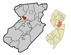
 Highland Park highlighted in Middlesex County. Inset: Location of Middlesex County highlighted in the State of New Jersey. |
|
 Census Bureau map of Highland Park, New Jersey |
|
| Coordinates: 40°30′03″N 74°25′40″W / 40.500795°N 74.427911°WCoordinates: 40°30′03″N 74°25′40″W / 40.500795°N 74.427911°W | |
| Country |
|
| State |
|
| County | Middlesex |
| Incorporated | March 15, 1905 |
| Government | |
| • Type | Borough |
| • Body | Borough Council |
| • Mayor | Gayle Brill Mittler (D, term ends December 31, 2019) |
| • Administrator | Kathleen Kovach |
| • Municipal clerk | Joan Hullings |
| Area | |
| • Total | 1.819 sq mi (4.712 km2) |
| • Land | 1.809 sq mi (4.686 km2) |
| • Water | 0.010 sq mi (0.026 km2) 0.56% |
| Area rank | 424th of 566 in state 21st of 25 in county |
| Elevation | 75 ft (23 m) |
| Population (2010 Census) | |
| • Total | 13,982 |
| • Estimate (2016) | 14,195 |
| • Rank | 176th of 566 in state 16th of 25 in county |
| • Density | 7,728.1/sq mi (2,983.8/km2) |
| • Density rank | 50th of 566 in state 3rd of 25 in county |
| Time zone | Eastern (EST) (UTC-5) |
| • Summer (DST) | Eastern (EDT) (UTC-4) |
| ZIP code | 08904 |
| Area code(s) | 732 / 908 |
| FIPS code | 3402331470 |
| GNIS feature ID | 0885252 |
| Website | hpboro |
|
Livingston Homestead
|
|
 |
|
| Location | 81 Harrison Avenue |
|---|---|
| Coordinates | 40°31′15″N 74°26′7″W / 40.52083°N 74.43528°W |
| Architectural style | Greek Revival |
| Part of | Livingston Manor Historic District (#04000672) |
| NRHP reference # | 02000215 |
| NJRHP # |
3950 |
| Significant dates | |
| Added to NRHP | March 20, 2002 |
| Designated CP | July 7, 2004 |
| Designated NJRHP | December 20, 2001 |
|
Livingston Manor Historic District
|
|
| Location | Parts of Cleveland, Grant, Harrison, Lawrence, Lincoln, Madison, and North Second Avenues and River Road |
|---|---|
| Coordinates | 40°30′5″N 74°26′17″W / 40.50139°N 74.43806°W |
| NRHP reference # | 04000672 |
| NJRHP # |
4289 |
| Added to NRHP | July 7, 2004 |
Highland Park is a borough in Middlesex County, New Jersey, United States. As of the 2010 United States Census, the borough's population was 13,982, reflecting a decline of 17 (-0.1%) from the 13,999 counted in the 2000 Census, which had in turn increased by 720 (+5.4%) from the 13,279 counted in the 1990 Census.
Highland Park was formed as a borough by an act of the New Jersey Legislature on March 15, 1905, when it broke away from what was then known as Raritan Township (present-day Edison). The borough was named for its location above the Raritan River.
The Native American Lenape people hunted on the hilly land along the Raritan River, and their trails crisscrossed the area. In 1685, John Inian bought land on both shores of the Raritan River and built two new landings downstream from the Assunpink Trail's fording place, which was later developed as Raritan Landing. He established a ferry service and the main road then was redirected to lead straight to the ferry landing. This river crossing was run by generations of different owners and a ferry house tavern operated for many years in the 18th century. A toll bridge replaced the ferry in 1795. The wood plank Albany Street Bridge was dismantled in 1848 and reconstructed in 1853. The present day stone arch road bridge was built in 1892. It became the Lincoln Highway Bridge in 1914 and was widened in 1925.
One of the earliest European settlers was Henry Greenland, who owned 384 acres (1.55 km2) of land and operated an inn along the Mill Brook section of the Assunpink Trail during the late 17th century. Others early settlers included George Drake, Reverend John Drake, and Captain Francis Drake, kinsmen of the famous explorer. In the early 18th century, a few wealthy Europeans including the Van Horns and Merrills settled on large tracts of land establishing an isolated farmstead pattern of development that would continue for the next 150 years.
...
Wikipedia


