Lichtenberg (locality)
| Lichtenberg | ||
|---|---|---|
| Quarter of Berlin | ||

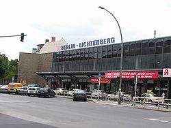
Lichtenberg railway station
|
||
|
||
| Coordinates: 52°31′16″N 13°28′48″E / 52.52111°N 13.48000°ECoordinates: 52°31′16″N 13°28′48″E / 52.52111°N 13.48000°E | ||
| Country | Germany | |
| State | Berlin | |
| City | Berlin | |
| Borough | Lichtenberg | |
| Founded | 1230 | |
| Area | ||
| • Total | 7.22 km2 (2.79 sq mi) | |
| Population (2008-06-30) | ||
| • Total | 32,295 | |
| • Density | 4,500/km2 (12,000/sq mi) | |
| Time zone | CET/CEST (UTC+1/+2) | |
| Postal codes | (nr. 1103) 10365, 10367 | |
| Vehicle registration | B | |
Lichtenberg is a locality (Ortsteil) of Berlin in the homonymous district (Bezirk) of Lichtenberg. Until 2001 it was an autonomous district with the localities of Fennpfuhl, Rummelsburg, Friedrichsfelde and Karlshorst.
The historic village of Lichtenberg, today also called Alt-Lichtenberg, was founded about 1230, due to the German colonization of the territory of Barnim. The settlement around the fieldstone church was first mentioned in a 1288 deed, its estates were acquired by the neighbouring City of Berlin in 1391.
Alt-Lichtenberg suffered severely during the Thirty Years' War and remained a small village at the Berlin gates until in the late 18th century Prussian noblemen like general Wichard Joachim Heinrich von Möllendorf built their residences here. In 1815 the Lichtenberg estate became a property of the Prussian chancellor Karl August von Hardenberg.
The village came to be a residential area and a suburb of Berlin from the mid 19th century on. A new town hall was erected in 1898 and in 1907 Lichtenberg received town privileges. Originally an independent city, it became part of Berlin in 1920 in the Greater Berlin Act.
Lichtenberg is located in the middle of its District. It borders with Friedrichshain (in Friedrichshain-Kreuzberg), Prenzlauer Berg (in Pankow), Fennpfuhl, Alt-Hohenschönhausen, Rummelsburg, Friedrichsfelde and Marzahn (in Marzahn-Hellersdorf). It has an area of 7.22 square kilometres (2.79 sq mi).
...
Wikipedia


