Liberty City, Texas
| Liberty City, Texas | |
|---|---|
| Census-designated place | |
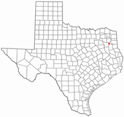
 Location of Liberty City, Texas |
|
 |
|
| Coordinates: 32°27′5″N 94°56′34″W / 32.45139°N 94.94278°WCoordinates: 32°27′5″N 94°56′34″W / 32.45139°N 94.94278°W | |
| Country | United States |
| State | Texas |
| County | Gregg |
| Area | |
| • Total | 6.10 sq mi (15.80 km2) |
| • Land | 6.09 sq mi (15.78 km2) |
| • Water | 0.008 sq mi (0.02 km2) |
| Elevation | 390 ft (119 m) |
| Population (2010) | |
| • Total | 2,351 |
| • Density | 386/sq mi (149.0/km2) |
| Time zone | Central (CST) (UTC-6) |
| • Summer (DST) | CDT (UTC-5) |
| ZIP code | 75662 |
| Area code(s) | 903 |
| FIPS code | 48-42616 |
| GNIS feature ID | 1339886 |
Liberty City is a census-designated place (CDP) in Gregg County, Texas, United States. The population was 2,351 at the 2010 census, up from 1,935 at the 2000 census.
Liberty City is located in western Gregg County at 32°27′5″N 94°56′34″W / 32.45139°N 94.94278°W (32.451388, -94.942781).Interstate 20 forms the southern edge of the CDP, with access from Exits 582 and 583. Texas State Highway 135 runs through the eastern side of Liberty City, leading north 8 miles (13 km) to Gladewater and southeast 6 miles (10 km) to Kilgore. Liberty City is 15 miles (24 km) southwest of the center of Longview and 24 miles (39 km) northeast of Tyler.
According to the United States Census Bureau, the CDP has a total area of 6.1 square miles (15.8 km2), of which 0.01 square miles (0.02 km2), or 0.13%, are water.
As of the census of 2000, there were 1,935 people, 690 households, and 569 families residing in the CDP. The population density was 493.0 people per square mile (190.6/km²). There were 747 housing units at an average density of 190.3/sq mi (73.6/km²). The racial makeup of the CDP was 93.02% White, 4.50% African American, 0.36% Native American, 0.16% Asian, 1.03% from other races, and 0.93% from two or more races. Hispanic or Latino of any race were 2.69% of the population.
...
Wikipedia
