Liberty, South Carolina
| Liberty, South Carolina | |
|---|---|
| City | |

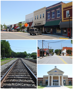
Top, left to right: Downtown Liberty, railroad, W. Front Street, Liberty High School
|
|
 Location of Liberty, South Carolina |
|
| Coordinates: 34°47′18″N 82°41′42″W / 34.78833°N 82.69500°WCoordinates: 34°47′18″N 82°41′42″W / 34.78833°N 82.69500°W | |
| Country | United States |
| State | South Carolina |
| County | Pickens |
| Area | |
| • Total | 4.3 sq mi (11.1 km2) |
| • Land | 4.3 sq mi (11.1 km2) |
| • Water | 0.0 sq mi (0.0 km2) |
| Elevation | 1,020 ft (311 m) |
| Population (2000) | |
| • Total | 3,009 |
| • Density | 705.0/sq mi (272.2/km2) |
| Time zone | Eastern (EST) (UTC-5) |
| • Summer (DST) | EDT (UTC-4) |
| ZIP code | 29657 |
| Area code(s) | 864 |
| FIPS code | 45-41380 |
| GNIS feature ID | 1246350 |
| Website | www.libertysc.com |
Liberty is a city in Pickens County, South Carolina, United States. It is part of the Greenville–Mauldin–Easley Metropolitan Statistical Area. The city was chartered on March 2, 1876.
How exactly Liberty got its name has been a source of debate over the years. There are no real historical accounts of why Liberty was given the name it was. The most popular—though probably mythical—story regarding the reason the area was named Liberty was put forth by Mrs. Annie Craig in 1936: “At the close of the Revolutionary war a religious meeting was being held at a church close to a spring near the present town of Liberty when the word came that Cornwallis had surrendered and the colonies had gained their independence. This church was named Liberty and it and the spring were located just beyond where the cemetery is now located, hence the name Liberty.”
Some have claimed that Liberty was once named Salubrity Springs, but was renamed Liberty in the late 19th century. References to early land records, however, suggests that such is not the case. While there are many records that refer to the area as Liberty Spring, there are no private or legal documents that contain a reference to Salubrity Spring. The first reference to Salubrity comes from the name of a farm purchased by the Rev. Allen Fuller, Universalist, in 1837. In 1839, Mr. Fuller set up a post office in his home, naming it Salubrity Post Office. This post office remained in operation until February, 1876, three years after the first official Liberty post office was established in 1873. Once the town of Liberty was chartered little more than a month after the Salubrity post office closed, the name Salubrity became little more than a memory.
Liberty today sits on land that was once part of the Cherokee Indians’ hunting ground. The Otarre, or Lower Hill Cherokees, had several thriving villages along the riverbanks in the area; perhaps the most notable example being the village of Keowee, located near the modern day Oconee and Pickens County line. Cherokee tribesmen, who often survived by growing crops, and tended to live in small villages, were in many ways more domesticated than other Native American tribes. The Cherokee also hunted game, believing that the foothills were a sacred hunting ground for deer, buffalo, and other large animals.
...
Wikipedia
