Lièpvre
| Lièpvre | ||
|---|---|---|

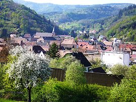
Lièpvre seen from Hoimbach
|
||
|
||
| Coordinates: 48°16′23″N 7°16′59″E / 48.2731°N 7.283°ECoordinates: 48°16′23″N 7°16′59″E / 48.2731°N 7.283°E | ||
| Country | France | |
| Region | Grand Est | |
| Department | Haut-Rhin | |
| Arrondissement | Colmar-Ribeauvillé | |
| Canton | Sainte-Marie-aux-Mines | |
| Intercommunality | Val d'Argent | |
| Government | ||
| • Mayor (2014–2020) | Pierrot Hestin | |
| Area1 | 12.55 km2 (4.85 sq mi) | |
| Population (2006)2 | 1,770 | |
| • Density | 140/km2 (370/sq mi) | |
| Time zone | CET (UTC+1) | |
| • Summer (DST) | CEST (UTC+2) | |
| INSEE/Postal code | 68185 /68660 | |
| Elevation | 234–930 m (768–3,051 ft) (avg. 275 m or 902 ft) |
|
|
1 French Land Register data, which excludes lakes, ponds, glaciers > 1 km² (0.386 sq mi or 247 acres) and river estuaries. 2Population without double counting: residents of multiple communes (e.g., students and military personnel) only counted once. |
||
1 French Land Register data, which excludes lakes, ponds, glaciers > 1 km² (0.386 sq mi or 247 acres) and river estuaries.
Lièpvre (French pronunciation: [ljɛvʁ]; German: Leberau) is a commune in the Haut-Rhin department in Grand Est in north-eastern France. A monastery was built here in the eighth century by Saint Fulrad, who filled it with relics of Saint Cucuphas and Saint Alexander.
The municipality is nestled in the Liepvrette river valley as the river descends from the main chain of the Vosges into the Col des Bagenelles, a mountain pass in the Vosges. The Liepvrette River runs northeast through Sainte-Marie-aux-Mines before reaching Lièpvre. Below Lièpvre, the river runs between the ruins of Frankenbourg castle in the north and the castle of Haut-Koenigsbourg in the south then across the municipality of Scherwiller. The Liepvrette then joins the Giessen River(Scheer in former times), which flows from the Val de Villé, before emptying into the River Ill Sélestat.
The municipality of Lièpvre is bordered by several summits in the Vosges: Brézouard (1229 m), Taennchel (992 m), and High-Koenigsbourg (775 m) to the south; Altenberg (880 m), Chalmont (697 m), Rocher du Coucou (819 m) and Frankenbourg (703 m) to the north. The Altenberg chain separates the Valley of Lièpvre from the Val de Villé. A road built in 1905 allowed access to Rombach-le-Franc, 2 km (1.2 mi) from Lièpvre. This road leads to the hamlet of Hingrie situated 7 km (4.3 mi) from Lièpvre and onto the Col de Fouchy. The village of Liepvre owes its name to the Liepvrette River and its origin to the priory of Lièpvre. Lièpvre is in the center of the valley and sits 275 meters above sea level.
...
Wikipedia


