Les Montils
| Les Montils | ||
|---|---|---|
| Commune | ||

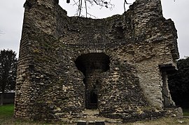
Ruins of a tower
|
||
|
||
| Coordinates: 47°29′46″N 1°17′52″E / 47.4961°N 1.2978°ECoordinates: 47°29′46″N 1°17′52″E / 47.4961°N 1.2978°E | ||
| Country | France | |
| Region | Centre-Val de Loire | |
| Department | Loir-et-Cher | |
| Arrondissement | Blois | |
| Canton | Blois-3 | |
| Intercommunality | Communauté d'agglomération de Blois | |
| Government | ||
| • Mayor (2014–2020) | Didier Coudert | |
| Area1 | 9.27 km2 (3.58 sq mi) | |
| Population (2014)2 | 1,952 | |
| • Density | 210/km2 (550/sq mi) | |
| Time zone | CET (UTC+1) | |
| • Summer (DST) | CEST (UTC+2) | |
| INSEE/Postal code | 41147 /41120 | |
| Elevation | 62–101 m (203–331 ft) (avg. 92 m or 302 ft) |
|
|
1 French Land Register data, which excludes lakes, ponds, glaciers > 1 km² (0.386 sq mi or 247 acres) and river estuaries. 2Population without double counting: residents of multiple communes (e.g., students and military personnel) only counted once. |
||
1 French Land Register data, which excludes lakes, ponds, glaciers > 1 km² (0.386 sq mi or 247 acres) and river estuaries.
Les Montils is a commune in the Loir-et-Cher department of central France.
Les Montils is at the edge of the Sologne, at an altitude of 80 m (approx.). This town is bordered by the Cosson in the north, through the Beuvron. To the west of the village, the Bièvre flows into Beuvron. At this point, there are numerous beavers.
...
Wikipedia


