Lenoir County, North Carolina
| Lenoir County, North Carolina | ||
|---|---|---|

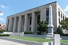
Lenoir County Courthouse in Kinston
|
||
|
||
 Location in the U.S. state of North Carolina |
||
 North Carolina's location in the U.S. |
||
| Founded | 1791 | |
| Named for | William Lenoir | |
| Seat | Kinston | |
| Largest city | Kinston | |
| Area | ||
| • Total | 403 sq mi (1,044 km2) | |
| • Land | 401 sq mi (1,039 km2) | |
| • Water | 2.2 sq mi (6 km2), 0.6% | |
| Population | ||
| • (2010) | 59,495 | |
| • Density | 149/sq mi (58/km²) | |
| Congressional districts | 1st, 3rd | |
| Time zone | Eastern: UTC-5/-4 | |
| Website | www |
|
Lenoir County is a county located in the U.S. state of North Carolina. As of the 2010 census, the population was 59,495. Its county seat is Kinston, located on the Neuse River, across which the county has its territory.
Lenoir County comprises the Kinston, NC Micropolitan Statistical Area.
The county was formed by European Americans in 1791 from the southern part of Dobbs County. It was named for William Lenoir (1751-1839), an officer in the American Revolutionary War who took part in the Battle of Kings Mountain. He was a prominent political leader; when the county was established, he was serving as Speaker of the North Carolina Senate.
According to the U.S. Census Bureau, the county has a total area of 403 square miles (1,040 km2), of which 401 square miles (1,040 km2) is land and 2.2 square miles (5.7 km2) (0.6%) is water.
As of the census of 2000, there were 59,648 people, 23,862 households, and 16,178 families residing in the county. The population density was 149 people per square mile (58/km²). There were 27,184 housing units at an average density of 68 per square mile (26/km²). The racial makeup of the county was 56.47% White, 40.43% Black or African American, 0.18% Native American, 0.34% Asian, 0.05% Pacific Islander, 1.88% from other races, and 0.66% from two or more races. 3.17% of the population were Hispanic or Latino of any race.
...
Wikipedia

