Leidschendam
| Leidschendam | |||
|---|---|---|---|
| Town | |||

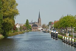
The Vliet entering Leidschendam
|
|||
|
|||
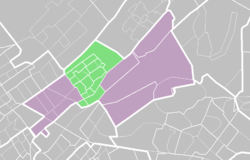
 Location in Leidschendam-Voorburg |
|||
 Location of Leidschendam-Voorburg in South Holland |
|||
| Coordinates: 52°5′N 4°24′E / 52.083°N 4.400°ECoordinates: 52°5′N 4°24′E / 52.083°N 4.400°E | |||
| Country |
|
||
| Province |
|
||
| Municipality |
|
||
| Area | |||
| • Total | 8.44 km2 (3.26 sq mi) | ||
| • Land | 8.22 km2 (3.17 sq mi) | ||
| • Water | 0.23 km2 (0.09 sq mi) | ||
| Elevation | 0 m (0 ft) | ||
| Population (2012) | |||
| • Total | 32,480 | ||
| • Density | 3,951/km2 (10,230/sq mi) | ||
| Demonym(s) | Leidschendammer | ||
| Time zone | CET (UTC+1) | ||
| • Summer (DST) | CEST (UTC+2) | ||
| Postcode | 2260–2268 | ||
| Area code | 070 | ||
Leidschendam is a town and former municipality in the province of South Holland of the Netherlands. Along with Voorburg and Stompwijk, it is part of the municipality Leidschendam-Voorburg.
The town's name has been in use for centuries and refers to the lock in the Vliet, near the historic city of Leiden. The settlement on the Northern side of the lock was known as 'Veur', until the formation of the municipality of Leidschendam in 1938. This recent date belies the long history of human habitation in this area, which predates the Roman occupation two thousand years ago.
Important driver for the development of the area was the Vliet canal, ferrying people and goods through Holland in the Middle Ages, and even in Roman times. As elsewhere in Holland, windmills were constructed to power local industry, such as a wheat grinding mill in 1594 and wood processing mills in 1643 and 1739 ('de Salamander' and 'de Hoop'). Veur became an independent municipality in the time of the short-lived Batavian Republic.
The Southern side of the Vliet was settled at a later date due to presence of extensive swamps. These were drained around 1200 by the Dutch counts, enabling the settlements of Stompwijk and Wilsveen to be established. Subsequently the peat industry flourished, and about twenty windmills were constructed for water management. In 1811, Stompwijk and Veur were combined to form Leidschendam, but this was reversed only six years later, although one mayor continued to serve both villages.
Starting in the closing years of the 19th century, the area started to change rapidly due to combined forces of the agricultural crisis, improved transportation in the area, and regional effects of the first and second World Wars. A growing number of government and industrial activities (the Dutch political capital of The Hague is nearby) and the associated housing demand transformed Veur from a rural into a suburban community. This led to a municipal reorganization and the formation of Leidschendam, in 1938. Both Leidschendam and Voorburg are now part of the agglomeration of the city of The Hague and are often regarded as its suburbs. Stompwijk is still a rural village, located a few miles Northeast of Leidschendam. All three were combined into the municipality of Leidschendam-Voorburg in 2002 (population: 73.832 in 2004, area: 35,6 km²) as an answer to a series of small annexations from surrounding municipalities made by The Hague. Hans van der Sluijs has been mayor of Leidschendam-Voorburg since 2007.
...
Wikipedia


