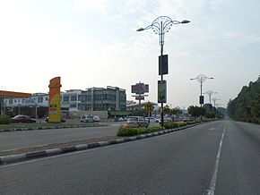
Lebuh Ayer Keroh
| Federal Route 143 | |
|---|---|
| Lebuh Ayer Keroh (Ayer Keroh Highway) |
|
 |
|
| Route information | |
| Length: | 11.8 km (7.3 mi) |
| Existed: | 1993 – present |
| History: | Completed in 1997 |
| Major junctions | |
| North end: |
Ayer Keroh Interchange |
|
|
|
| South end: |
Batu Berendam Tun Abdul Ghafar Intersections |
| Location | |
| Primary destinations: |
Melaka City Ayer Keroh Hang Tuah Jaya Durian Tunggal |
| Highway system | |
Lebuh Ayer Keroh, Federal Route 143, also known as Lebuhraya Ayer Keroh or Ayer Keroh Highway, is the main dual-carriageway highway that connects Melaka City of Malacca, Malaysia to the North-South Expressway via Ayer Keroh Interchange. Ayer Keroh, the main satellite town of Melaka is located along the road. Lebuh Ayer Keroh used to be Melaka State Route M31 before being recommissioned by Malaysian Public Works Department (Jabatan Kerja Raya (JKR)). Before 1993, most of the road was a two-lane road before it was upgraded to a dual-carriageway in 1993 (Ayer Keroh toll plaza-Graha Makmur) and in 1997 (entire route).
The Kilometre Zero of the Federal Route 143 starts at Jalan Durian Tunggal junctions near Ayer Keroh toll plaza of the Ayer Keroh Interchange.
At most sections, the Federal Route 143 was built under the JKR R5 road standard, allowing maximum speed limit of up to 90 km/h.
...
Wikipedia

