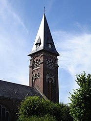
Le Hamel, Somme
| Le Hamel | |
|---|---|
| Commune | |
 |
|
| Coordinates: 49°53′00″N 2°34′00″E / 49.8833°N 2.5667°ECoordinates: 49°53′00″N 2°34′00″E / 49.8833°N 2.5667°E | |
| Country | France |
| Region | Hauts-de-France |
| Department | Somme |
| Arrondissement | Amiens |
| Canton | Corbie |
| Intercommunality | Val de Somme |
| Government | |
| • Mayor (2014–2020) | Stéphane Chevin |
| Area1 | 9.12 km2 (3.52 sq mi) |
| Population (2014)2 | 510 |
| • Density | 56/km2 (140/sq mi) |
| Time zone | CET (UTC+1) |
| • Summer (DST) | CEST (UTC+2) |
| INSEE/Postal code | 80411 /80800 |
| Elevation | 28–101 m (92–331 ft) (avg. 83 m or 272 ft) |
|
1 French Land Register data, which excludes lakes, ponds, glaciers > 1 km² (0.386 sq mi or 247 acres) and river estuaries. 2Population without double counting: residents of multiple communes (e.g., students and military personnel) only counted once. |
|
1 French Land Register data, which excludes lakes, ponds, glaciers > 1 km² (0.386 sq mi or 247 acres) and river estuaries.
Le Hamel is a commune in the Somme department and Hauts-de-France region of northern France.
Le Hamel is situated some 20 km east of Amiens in the valley of the Somme. The surrounding district is the historical Santerre, a lightly wooded and agricultural plateau.
The settlement is first documented in 1184 as belonging to the powerful abbey of Corbie. The name has the same root as hameau ("hamlet"), a small rural settlement.
Like many places in the region, Le Hamel has experienced the ravages of war through the ages, from the conflicts between the French kings and their English, Burgundian, and Spanish adversaries to the battles of the First World War. It was a pivotal place in the latter conflict as the site of the Battle of Hamel which took place on 4 July 1918 and was a prelude to the summer offensive of 8 August later in the same year.
The Mairie
The High Street
...
Wikipedia


