Lawrenceburg, Indiana
| Lawrenceburg, Indiana | |
|---|---|
| City | |

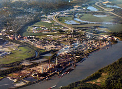
Lawrenceburg from the air, looking northwest. Tanner's Creek Generating Station is at bottom left.
|
|
 Location in the state of Indiana |
|
| Coordinates: 39°5′46″N 84°51′28″W / 39.09611°N 84.85778°WCoordinates: 39°5′46″N 84°51′28″W / 39.09611°N 84.85778°W | |
| Country | United States |
| State | Indiana |
| County | Dearborn |
| Government | |
| • Mayor | Kelly Mollaun (R) |
| Area | |
| • Total | 5.21 sq mi (13.49 km2) |
| • Land | 4.94 sq mi (12.79 km2) |
| • Water | 0.27 sq mi (0.70 km2) 5.18% |
| Elevation | 479 ft (146 m) |
| Population (2010) | |
| • Total | 5,042 |
| • Estimate (2012) | 5,020 |
| • Density | 1,020.6/sq mi (394.1/km2) |
| Time zone | EST (UTC-5) |
| • Summer (DST) | EDT (UTC-4) |
| ZIP code | 47025 |
| Area code(s) | 812 |
| FIPS code | 18-42462 |
| GNIS feature ID | 0437674 |
| Website | lawrenceburg-in.com |
Lawrenceburg is a city in Dearborn County, Indiana, United States. The population was 5,042 at the 2010 census. The city is the county seat and largest city of Dearborn County. Lawrenceburg is in southeast Indiana, on the Ohio River west of Cincinnati.
Founded in 1802, Lawrenceburg was named for the maiden name of founder Samuel C. Vance's wife.
In the 19th century Lawrenceburg became an important trading center for riverboats on the Ohio River.
The Dearborn County Courthouse, Downtown Lawrenceburg Historic District, Hamline Chapel United Methodist Church, Daniel S. Major House, and Vance-Tousey House are listed on the National Register of Historic Places.
Lawrenceburg is located at 39°5′46″N 84°51′28″W / 39.09611°N 84.85778°W (39.096015, -84.857783).
According to the 2010 census, Lawrenceburg has a total area of 5.21 square miles (13.49 km2), of which 4.94 square miles (12.79 km2) (or 94.82%) is land and 0.27 square miles (0.70 km2) (or 5.18%) is water.
As of the census of 2010, there were 5,042 people, 2,057 households, and 1,142 families residing in the city. The population density was 1,020.6 inhabitants per square mile (394.1/km2). There were 2,313 housing units at an average density of 468.2 per square mile (180.8/km2). The racial makeup of the city was 93.5% White, 3.0% African American, 0.3% Native American, 0.8% Asian, 0.3% from other races, and 2.2% from two or more races. Hispanic or Latino of any race were 1.2% of the population.
...
Wikipedia
