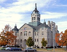
Lawrence County, Missouri
| Lawrence County, Missouri | |
|---|---|

Lawrence County Courthouse in Mt. Vernon
|
|
 Location in the U.S. state of Missouri |
|
 Missouri's location in the U.S. |
|
| Founded | February 14, 1845 |
| Named for | James Lawrence |
| Seat | Mount Vernon |
| Largest city | Monett |
| Area | |
| • Total | 613 sq mi (1,588 km2) |
| • Land | 612 sq mi (1,585 km2) |
| • Water | 1.6 sq mi (4 km2), 0.3% |
| Population (est.) | |
| • (2015) | 38,180 |
| • Density | 63/sq mi (24/km²) |
| Congressional district | 7th |
| Time zone | Central: UTC-6/-5 |
| Lawrence County, Missouri | ||||
|---|---|---|---|---|
| Elected countywide officials | ||||
| Assessor | Doug Bowerman | Republican | ||
| Circuit Clerk | Steven W. Kahre | Republican | ||
| County Clerk | Gary Emerson | Republican | ||
| Collector | Kelli McVey | Republican | ||
|
Commissioner (Presiding) |
Sam Goodman | Republican | ||
|
Commissioner (District 1) |
Joe Ruscha | Republican | ||
|
Commissioner (District 2) |
Rodney Barnes | Republican | ||
| Coroner | Scott Lakin | Republican | ||
| Prosecuting Attorney | Don Trotter | Republican | ||
| Public Administrator | Pam Fobair | Republican | ||
| Recorder | Pam Robertson | Republican | ||
| Sheriff | Brad DeLay | Republican | ||
| Surveyor | Aaron Austin | Republican | ||
| Treasurer | Kathy Fairchild | Republican | ||
| Lawrence County, Missouri | ||
|---|---|---|
| 2008 Republican primary in Missouri | ||
| John McCain | 1,412 (26.19%) | |
| Mike Huckabee | 2,628 (48.75%) | |
| Mitt Romney | 1,022 (18.96%) | |
| Ron Paul | 232 (4.30%) | |
| Lawrence County, Missouri | ||
|---|---|---|
| 2008 Democratic primary in Missouri | ||
| Hillary Clinton | 2,040 (61.58%) | |
| Barack Obama | 1,155 (34.86%) | |
| John Edwards (withdrawn) | 93 (2.81%) | |
Lawrence County is a county located in the southwest portion of the U.S. state of Missouri. As of the 2010 census, the population was 38,634. Its county seat is Mount Vernon. The county was organized in 1845 and named for James Lawrence, a naval officer from the War of 1812 known for his battle cry, "Don't give up the ship!"
A previous Lawrence County, established in 1815 with its county seat at what is now Davidsonville Historic State Park in Arkansas, covered much of what is now southern Missouri and the northern third of Arkansas; it became Lawrence County, Arkansas when Arkansas Territory was created from Missouri Territory in 1819. Just before that, in 1818, Missouri divided its part of the old Lawrence County into Wayne County and Madison County; those were later divided into others, including the present Lawrence County.
According to the U.S. Census Bureau, the county has a total area of 613 square miles (1,590 km2), of which 612 square miles (1,590 km2) is land and 1.6 square miles (4.1 km2) (0.3%) is water.
As of the census of 2000, there were 35,204 people, 13,568 households, and 9,728 families residing in the county. The population density was 57 people per square mile (22/km²). There were 14,789 housing units at an average density of 24 per square mile (9/km²). The racial makeup of the county was 95.68% White, 0.27% Black or African American, 0.76% Native American, 0.22% Asian, 0.02% Pacific Islander, 1.67% from other races, and 1.37% from two or more races. Approximately 3.39% of the population were Hispanic or Latino of any race.
...
Wikipedia
