Laubach (Eifel)
| Laubach | ||
|---|---|---|
|
||
| Coordinates: 50°14′3″N 7°4′28″E / 50.23417°N 7.07444°ECoordinates: 50°14′3″N 7°4′28″E / 50.23417°N 7.07444°E | ||
| Country | Germany | |
| State | Rhineland-Palatinate | |
| District | Cochem-Zell | |
| Municipal assoc. | Kaisersesch | |
| Government | ||
| • Mayor | Manfred Adams | |
| Area | ||
| • Total | 3.58 km2 (1.38 sq mi) | |
| Elevation | 550 m (1,800 ft) | |
| Population (2015-12-31) | ||
| • Total | 636 | |
| • Density | 180/km2 (460/sq mi) | |
| Time zone | CET/CEST (UTC+1/+2) | |
| Postal codes | 56759 | |
| Dialling codes | 02653 | |
| Vehicle registration | COC | |
| Website | www.laubach-eifel.de | |
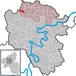
Laubach is an Ortsgemeinde (a municipality belonging to a Verbandsgemeinde, a collective municipality) in the Cochem-Zell district in Rhineland-Palatinate, Germany. It belongs to the Verbandsgemeinde of Kaisersesch, whose seat is Kaisersesch. Laubach is a state-recognized tourist area.
The municipality lies in the Eifel, roughly 3 kilometres (1.9 mi) west of Kaisersesch, at an elevation of 550 metres (1,800 ft) above sea level. Laubach is on Autobahn A 48, between Koblenz and Trier.
The municipality’s name probablyly has its roots in the Middle High German lôbach. Lob and the Modern High German Laub (a cognate of the English “leaf”) refer to a forest, while ach means a boggy stretch of ground.
Several finds in the Laubach area provide clues about early settlers; a late Bronze Age barrow exists in the municipality, and the Romans left stone traces. The first mention of Laubach was in 1455, when “court, people and revenue at Laubach” were sold to the Counts of Virneburg (a noble family first mentioned in 1024 and enfeoffed by the Archbishop of Trier). In 1548, the Electorate of Trier assumed the lordly rights.
For centuries, the village’s primary livelihood was slate mining. This is documented as far back as 1695, although smaller pits were worked before that. The last slate pit was closed in 1959, after it flooded.
...
Wikipedia


