Laton, California
| Laton | |
|---|---|
| census-designated place | |
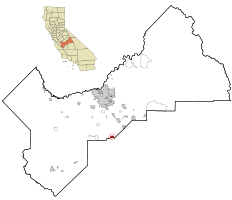
 Location in Fresno County and the state of California |
|
| Location in the United States | |
| Coordinates: 36°26′00″N 119°41′12″W / 36.43333°N 119.68667°WCoordinates: 36°26′00″N 119°41′12″W / 36.43333°N 119.68667°W | |
| Country |
|
| State |
|
| County | Fresno |
| Government | |
| • State Senator | Anthony Cannella (R) |
| • State Assembly | Joaquin Arambula (D) |
| • U. S. Congress | David Valadao (R) |
| Area | |
| • Total | 1.937 sq mi (5.017 km2) |
| • Land | 1.937 sq mi (5.017 km2) |
| • Water | 0 sq mi (0 km2) 0% |
| Elevation | 259 ft (79 m) |
| Population (2010) | |
| • Total | 1,824 |
| • Density | 940/sq mi (360/km2) |
| Time zone | PST (UTC-8) |
| • Summer (DST) | PDT (UTC-7) |
| ZIP code | 93242 |
| Area code(s) | 559 |
| FIPS code | 06-40746 |
| GNIS feature IDs | 1660899, 2408585 |
Laton /ˈleɪtən/ is a census-designated place (CDP) in Fresno County, California, United States. The population was 1,824 at the 2010 census, up from 1,236 at the 2000 census. Laton is located 23 miles (37 km) south-southeast of Fresno, at an elevation of 259 feet (79 m).
According to the United States Census Bureau, the CDP has a total area of 1.9 square miles (4.9 km2), all of it land.
Laton's first post office opened in 1900, having been transferred from Lillis. The name honors Charles A. Laton, who owned the Rancho Laguna de Tache Mexican land grant.
The 2010 United States Census reported that Laton had a population of 1,824. The population density was 941.5 people per square mile (363.5/km²). The racial makeup of Laton was 1,001 (54.9%) White, 4 (0.2%) African American, 13 (0.7%) Native American, 10 (0.5%) Asian, 0 (0.0%) Pacific Islander, 744 (40.8%) from other races, and 52 (2.9%) from two or more races. Hispanic or Latino of any race were 1,393 persons (76.4%).
...
Wikipedia

