Lancaster, Kentucky
| Lancaster, Kentucky | |
|---|---|
| City | |

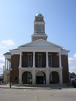
Garrard County courthouse in Lancaster
|
|
 Location of Lancaster, Kentucky |
|
| Coordinates: 37°37′7″N 84°34′46″W / 37.61861°N 84.57944°WCoordinates: 37°37′7″N 84°34′46″W / 37.61861°N 84.57944°W | |
| Country | United States |
| State | Kentucky |
| County | Garrard |
| Established | 1797 |
| Incorporated | 1837 |
| Named for | Lancaster, Pennsylvania |
| Area | |
| • Total | 1.9 sq mi (5.0 km2) |
| • Land | 1.9 sq mi (5.0 km2) |
| • Water | 0.0 sq mi (0.0 km2) |
| Elevation | 1,027 ft (313 m) |
| Population (2010) | |
| • Total | 3,442 |
| • Density | 1,774/sq mi (685.1/km2) |
| Time zone | Eastern (EST) (UTC-5) |
| • Summer (DST) | EDT (UTC-4) |
| ZIP codes | 40444, 40446 |
| Area code(s) | 859 |
| FIPS code | 21-43840 |
| GNIS feature ID | 0495946 |
| Website | www |
Lancaster local /ˈlæŋkəstər/ is a home rule-class city in Garrard County, Kentucky, in the United States. It is the seat of its county. As of the year 2010 U.S. census, the city population was 3,442.
Located south of Lexington, Lancaster is the site of the Kennedy House, sometimes said to have been the setting for Uncle Tom's Cabin. The Civil War training base Camp Dick Robinson was located nearby. The Garrard County High School in town is the home of the "Golden Lions".
Lancaster is located west of the center of Garrard County at 37°37′7″N 84°34′46″W / 37.61861°N 84.57944°W (37.618625, -84.579433).U.S. Route 27 passes through the city, leading north 35 miles (56 km) to Lexington and south 39 miles (63 km) to Somerset. Kentucky Route 52 crosses US 27 in the center of Lancaster, leading east and northeast 23 miles (37 km) to Richmond, and west 11 miles (18 km) to Danville. Lancaster is 3 miles (5 km) east of the Dix River, a north-flowing tributary of the Kentucky River.
...
Wikipedia
