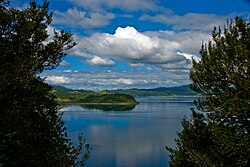
Lake Rotoma
| Lake Rotoma | |
|---|---|
 |
|
| Location | Rotorua District, Bay of Plenty Region, North Island |
| Coordinates | 38°02′51″S 176°35′16″E / 38.0476°S 176.5878°ECoordinates: 38°02′51″S 176°35′16″E / 38.0476°S 176.5878°E |
| Lake type | Crater lake |
| Basin countries | New Zealand |
| Max. length | 5.2 km (3.2 mi) |
| Max. width | 4.7 km (2.9 mi) |
| Surface area | 11.2 km2 (4.3 sq mi) |
| Average depth | 38.6 m (127 ft) |
| Max. depth | 83 m (272 ft) |
| Surface elevation | 316 m (1,037 ft) |
| Islands | 1 sunken island |
| References | |
Lake Rotoma is the fourth largest lake of the 11 lakes in the Rotorua Lakes district, or the Hot Lakes district as it was known in the early decades of the 20th century. The Rotorua lakes are located in New Zealand's North Island in the Bay of Plenty Region. Lake Rotoma is the easternmost in the chain of three lakes to the northeast of Lake Rotorua The other two are Lake Rotoiti and Lake Rotoehu. Rotoma is located halfway between the city of Rotorua and town of Whakatane.
Lake Rotoma has a high water quality with visibility up to around 13 metres deep. The lake has a maximum depth of 83 metres in the northern part and 73.5 metres in the southern part.
Lake Rotoma was formed within the Rotoma caldera when lava flows from a large crater explosion blocked its outlet 9,500 years ago. The hills fringing the south and east of the lake are made up of Rhyolite from Haroharo and Tarawera, and this has meant that Lake Rotoma has no surface outlets. However, the presence of springs has suggested an underground discharge of lake waters. The water level of Rotoma reaches an excessive high or low level every 10–15 years. In times of extreme low levels, the sunken island "Motutara" in the lake may be exposed.
Before the road around Lake Rotoma was constructed, there were several Māori trails over the Rotoma hill which could be used to get between Rotorua and the Eastern Bay of Plenty by foot, but these trails were too narrow and uneven to be used by horses. Travellers from Rotorua could only get as far as Tikitere on the rough track. In May 1895 work commenced on the Tikitere to Rotoma road. By July, there were three road gangs working on different sections of the road, and work began over the difficult section over the Rotoma hill in the summer of 1895–1896. A proper road was also constructed from Te Ngae in Rotorua through to Tikitere.
Once the road was completed, horse-drawn traffic commenced and public coaching services began. The first such service was started in 1907 by the R.M. Company, who ran a service twice a week from Rotorua to Opotiki carrying mail and up to three passengers. In 1910 the R.M. Company upgraded to a large coach drawn by five horses which could hold 10 passengers. In 1916 Colletts of Rotorua started the first regular motor car service, using Cadillac service cars. The average travel time from Rotorua to Whakatane was 5 hours, but like the horse-drawn coaches, the service cars could take up to 9 hours to travel this distance depending on the driving conditions. The road surface gradually improved, decreasing the travel time to 3 hours by the late 1920s. Today, this journey takes just one hour and 20 minutes.
...
Wikipedia
