Mount Tarawera
| Mount Tarawera | |
|---|---|

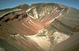
Fissure formed during 1886 Tarawera eruption
|
|
| Highest point | |
| Elevation | 1,111 m (3,645 ft) |
| Coordinates | 38°13′00″S 176°31′00″E / 38.21667°S 176.51667°ECoordinates: 38°13′00″S 176°31′00″E / 38.21667°S 176.51667°E |
| Geography | |
| Geology | |
| Mountain type | Lava dome with fissure vent |
| Volcanic arc/belt | Taupo Volcanic Zone |
| Last eruption | May 1981 (Waimangu) June 1951 (Rotomahana) June to August 1886 (Tarawera) |
Mount Tarawera is the volcano responsible for one of New Zealand's largest historic eruptions. Located 24 kilometres southeast of Rotorua in the North Island, it consists of a series of rhyolitic lava domes that were fissured down the middle by an explosive basaltic eruption in 1886, which killed an estimated 120 people. These fissures run for about 17 kilometres northeast-southwest.
The volcano's component domes include Ruawahia Dome (the highest at 1111 metres), Tarawera Dome and Wahanga Dome. It is surrounded by several lakes, most of which were created or drastically altered by the 1886 eruption. These lakes include Lakes Tarawera, Rotomahana, Rerewhakaaitu, Okataina, Okareka, Tikitapu (Blue Lake) and Rotokakahi (Green Lake). The Tarawera River runs northeastwards across the northern flank of the mountain from Lake Tarawera.
Mount Tarawera erupted around 1315. The ash thrown from this event may have affected temperatures around the globe and precipitated the Great Famine of 1315–17 in Europe.
Shortly after midnight on the morning of 10 June 1886, a series of more than 30 increasingly strong earthquakes were felt in the Rotorua area and an unusual sheet lightning display was observed from the direction of Tarawera. At around 2:00 am a larger earthquake was felt and followed by the sound of an explosion. By 2:30 am Mount Tarawera's three peaks had erupted, blasting three distinct columns of smoke and ash thousands of metres into the sky. At around 3.30 am, the largest phase of the eruption commenced; vents at Rotomahana produced a pyroclastic surge that destroyed several villages within a 6 kilometre radius, and the Pink and White Terraces appeared to be obliterated.
...
Wikipedia

