Lake Moogerah
| Moogerah Dam | |
|---|---|

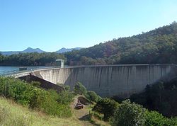
The Moogerah Dam wall, in 2011
|
|
|
Location of the Moogerah Dam
in Queensland |
|
| Country | Australia |
| Location | South East Queensland |
| Coordinates | 28°1′48″S 152°32′56″E / 28.03000°S 152.54889°ECoordinates: 28°1′48″S 152°32′56″E / 28.03000°S 152.54889°E |
| Purpose | |
| Status | Operational |
| Construction began | 1959 |
| Opening date | 1961 |
| Operator(s) | SEQ Water |
| Dam and spillways | |
| Type of dam | Arch dam |
| Impounds | Reynolds Creek |
| Height | 38 m (125 ft) |
| Length | 219 m (719 ft) |
| Dam volume | 23×103 m3 (810×103 cu ft) |
| Spillway type | Uncontrolled |
| Spillway capacity | 740 m3/s (26,000 cu ft/s) |
| Reservoir | |
| Creates | Lake Moogerah |
| Total capacity | 83,700 ML (1.84×10¹⁰ imp gal; 2.21×10¹⁰ US gal) |
| Catchment area | 228 km2 (88 sq mi) |
| Surface area | 827 ha (2,040 acres) |
| Normal elevation | 154.91 m (508.2 ft) AHD |
|
Website www.seqwater.com.au |
|
The Moogerah Dam is a mass concrete double curvature arch dam with a un-gated spillway across the Reynolds Creek that is located in the South East region of Queensland, Australia. The main purposes of the dam are for irrigation of the Reynolds Creek and for supply of potable water to Warrill Creek and farmers in the Warrill Valley. The impounded reservoir is called Lake Moogerah.
Moogerah is derived from the Aboriginal word Moojirah, meaning "home of the thunderstorm."
The dam is located above the Fassifern Valley, approximately 60 kilometres (37 mi) southwest of Ipswich. Aratula is the nearest town, approximately 11 kilometres (6.8 mi) from the dam and the nearest major centre is Boonah. The primary inflow of the reservoir is the Reynolds Creek, a tributary of the Bremer River.
Construction on the dam began in 1959, although land for the project was resumed as early as 1916. Completed in 1961 as the central catchment of the Warrill Valley Water Supply Scheme, the concrete dam structure is 38 metres (125 ft) high and 219 metres (719 ft) long and allows access to Mount Edwards in Moogerah Peaks National Park. The 315-thousand-cubic-metre (11.1×10⁶ cu ft) dam wall holds back the 83,765-megalitre (1.8426×10¹⁰ imp gal; 2.2128×10¹⁰ US gal) reservoir when at full capacity. From a catchment area of 228 square kilometres (88 sq mi) that includes much of the north–eastern slopes of the Main Range, the dam creates Lake Moogerah, with a surface area of 827 hectares (2,040 acres). The uncontrolled spillway has a discharge capacity of 740 cubic metres per second (26,000 cu ft/s). Initially managed by SunWater, management of the dam was transferred to Seqwater in July 2008 as part of a water security project in the South East Queensland region, known as the South East Queensland Water Grid.
...
Wikipedia

