Lake Mendota
| Lake Mendota | |
|---|---|

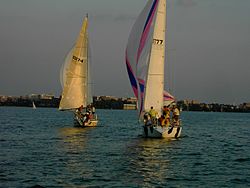
Boats headed toward south shore (downtown Madison).
|
|
| Location |
Dane County, Wisconsin, United States |
| Coordinates | 43°06′24″N 89°25′29″W / 43.10667°N 89.42472°WCoordinates: 43°06′24″N 89°25′29″W / 43.10667°N 89.42472°W |
| Primary inflows | Yahara River |
| Primary outflows | Yahara River |
| Catchment area | 562 km2 (217 sq mi) |
| Basin countries | United States |
| Surface area | 9,740 acres (3,940 ha) (39.4 sq. km) |
| Max. depth | 83 ft (25 m) |
| Residence time | 4.5 years |
| Shore length1 | 21.6 mi (34.8 km) |
| Surface elevation | 259 m (850 ft) |
| Frozen | December 20 (average freezing date) |
| Settlements | Madison, Middleton, Shorewood Hills, Maple Bluff, Westport |
| 1 Shore length is not a well-defined measure. | |
Lake Mendota is the northernmost and largest of the four lakes in Madison, Wisconsin. The lake borders Madison on the north, east and south, Middleton on the west, Shorewood Hills on the southwest, Maple Bluff on the northeast, and Westport on the northwest.
The shorelines of Lake Mendota and Monona define the isthmus upon which Madison was built, with the lakes connected by the Yahara River. Much of it is lined with expensive luxury homes and condominiums. The banks of the lake also contain protected natural areas and parks, including James Madison Park, as well as university housing, the UW Student Union and a handful of hotels and restaurants. Summers bring boaters out in force, especially on the weekends, though Lake Mendota is rarely crowded. There are several boat launching sites and two major marinas serving the lake. On a typical summer day, the lake is filled with those engaging in water sports, including fishing, water-skiing, wakeboarding, tubing, canoeing, wind-surfing, kayaking, and sailing. With an average freeze date of December 20, Lake Mendota is used in the winter by sports enthusiasts for ice-boating, ice-skating, ice fishing, cross country skiing, ice hockey and snowkiting.
...
Wikipedia
