Lake Junín
| Lake Junin | |
|---|---|
| Chinchaycocha | |
 |
|
| Coordinates | 11°01′S 76°07′W / 11.017°S 76.117°WCoordinates: 11°01′S 76°07′W / 11.017°S 76.117°W |
| Primary outflows | Upamayu-Mantaro River |
| Basin countries | Peru |
| Surface area | 529.88 km2 (204.59 sq mi) |
| Max. depth | 12 m (39 ft) |
| Surface elevation | 4,082.7 m (13,395 ft) |
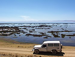
Lake Junin (who-neen; IPA: [xuˈnin]) (Spanish Lago Junín, named after the nearby town of Junin) or Chinchaycocha (possibly from Quechua chincha, chinchay north, northern, chinchay ocelot, qucha lake, lagoon, "northern lake" or "ocelot lake") is the largest lake entirely within Peruvian territory. Even though Lake Titicaca has a much larger area, its eastern half is located on Bolivian territory. Lake Junin is an important birdwatching destination in the country.
Most of the lake is located in the Junin Province of the Junin Region, its northwestern tip belongs to the Pasco Province which is in the Pasco Region. The surface elevation of the lake is located at 4,082.7 m (13,395 ft) above sea level.
Lake Junin is surrounded by emergent vegetation, which in some places can reach 6 km (3.7 mi) wide and become so dense that it is impenetrable. The fish fauna is abundant but includes several introduced species. The introduced trout have been implicated in the decline of some native species.
The lake is within the Amazon catchment. There is a hydroelectric power station which regulates the water level of the lake at the outflow of the lake, through the Upamayu Dam. In years of abundant rains, fluctuations in the water level are moderate, but in years of drought water level may drop 1.5–2 m (4.9–6.6 ft) leaving extensive areas exposed. The deepest part of the lake, which is located about 10 kilometres (6.2 mi) off Huayre, is 12 m (39 ft) deep.
...
Wikipedia
