Lake Disappear
| Lake Disappear | |
|---|---|

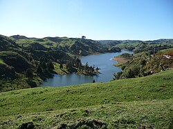
Lake Disappear when full viewed from Kawhia Rd (July 2008)
|
|
|
Lake Disappear is in the Waikato Region of the North Island.
|
|
| Location | Waikato District, Waikato Region, North Island |
| Coordinates | 37°55′S 174°55′E / 37.917°S 174.917°ECoordinates: 37°55′S 174°55′E / 37.917°S 174.917°E |
| Lake type | intermittent lake |
| Primary inflows | Pakihi Stream |
| Primary outflows | sinkhole |
| Catchment area | 7 km2 (2.7 sq mi) |
| Basin countries | New Zealand |
| Max. length | 2 km (1.2 mi) |
| Average depth | up to 15 m (49 ft) |
| Surface elevation | 170 m (560 ft) |
Lake Disappear is an intermittent lake (see also Turlough (lake) and Polje) situated in the North Island of New Zealand, just over 20 km from Raglan, 4 km beyond Bridal Veil waterfall. It has also been described as a solution lake. The south end can be seen from Kawhia Rd and, when the north end is full, it can be seen from the point which is at the end of Plateau Rd on the Pipiwharauroa Way.
Lake Disappear lies in a valley dammed by a lava flow (similar to the one which also formed Bridal Veil waterfall - see map below) and drained through a limestone sinkhole. The lava flow, which covered the limestone, was part of the Okete Volcanics about 2 million years ago, coming from a vent on Whataipu (see map), just over a kilometre away. Page 43 of the 'Geology of the Raglan-Kawhia Area' says, “Only a few specific areas within the larger catchments are prone to flooding where river flow is restricted, most notably at Lake Disappear (R15/795635 [now on Topo maps BD32 & BE32]) Here, the Pakoka River [should be Pakihi – Pakoka is the next valley with Bridal Veil fall] drains underground through limestone (Elgood Limestone). During times of prolonged heavy rain, water backs up behind the outlet to form a sizable lake over what are normally dry alluvial flats.”
Elgood Limestone (an outcrop is in the photo - see Gallery - to the left) is part of the Glen Massey Formation. The geology guide describes it as, “forming prominent bluffs or surface outcrops displaying solution channels, lapiez, and sinkholes, and is everywhere a light grey, flaggy limestone containing up to 95% CaCO3. Glauconite is common throughout, together with Mesozoic pebbles and greensand near the base”. About its late Whaingaroan (about 27 million years ago) creation, it says, “The change from estuarine, shallow brackish water conditions (Mangakotuku Formation), to fully marine, open sea, aerobic conditions (Glen Massey Formation) is evidenced by near shore accumulation of the bioclastic Elgood Limestone, onlap of the succeeding Dunphail Siltstone, and subsequent deposition of Ahirau Sandstone in an inner to mid shelf environment.”
...
Wikipedia

