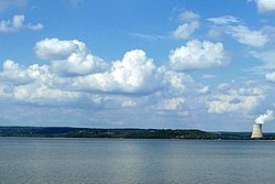
Lake Dardanelle
| Lake Dardanelle | |
|---|---|
 |
|
| Location | Arkansas |
| Coordinates | 35°17′N 93°14′W / 35.283°N 93.233°WCoordinates: 35°17′N 93°14′W / 35.283°N 93.233°W |
| Type | reservoir |
| Primary inflows | Arkansas River |
| Primary outflows | Arkansas River |
| Basin countries | United States |
| Surface area | 40,000 acres (160 km2) |
| Shore length1 | 315 miles (510 km) |
| Surface elevation | 338 feet (103 m) |
| 1 Shore length is not a well-defined measure. | |
Lake Dardanelle is a major reservoir on the Arkansas River in Arkansas, USA. Russellville lies on Lake Dardanelle, and the lake provides many recreational opportunities. Lake Dardanelle covers nearly 40,000 acres (160 km2) of land, which provides lots of area for boating, fishing, picnicking, camping and scenic views. The lake extends from Dardanelle Lock and Dam (35°14′55″N 93°10′15″W / 35.24861°N 93.17083°W) near Dardanelle, into Pope, Yell, Logan, Johnson and Franklin Counties. The lake reaches 50 miles (80 km) upstream the Arkansas River and has 315 miles (510 km) of shoreline. Each recreational park on Dardanelle has drinking water, picnic tables and toilet facilities. Most have trailer dump stations, boat launch ramps and electrical sites.
The only nuclear power plant in Arkansas, Arkansas Nuclear One, is located on the northeastern shore of Lake Dardanelle.
Winthrop Rockefeller Lake starts immediately below the Dardanelle Dam and extends almost 30 miles (50 km) southeast to the Arthur V. Ormond Lock and Dam near Morrilton. These lakes have been popular with fishermen because of their large populations of catfish, white bass, bream,crappie and other species of bass.
...
Wikipedia
