Franklin County, Arkansas
| Franklin County, Arkansas | |
|---|---|

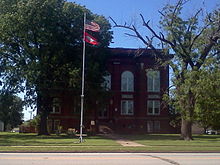
Franklin County Courthouse, Charleston
|
|
 Location in the U.S. state of Arkansas |
|
 Arkansas's location in the U.S. |
|
| Founded | December 19, 1837 |
| Named for | Benjamin Franklin |
| Seat |
Ozark (northern district); Charleston (southern district) |
| Largest city | Ozark |
| Area | |
| • Total | 620 sq mi (1,606 km2) |
| • Land | 609 sq mi (1,577 km2) |
| • Water | 11 sq mi (28 km2), 1.7% |
| Population (est.) | |
| • (2015) | 17,702 |
| • Density | 30/sq mi (12/km²) |
| Congressional district | 4th |
| Time zone | Central: UTC-6/-5 |
Franklin County is a county located in the U.S. state of Arkansas. As of the 2010 census, the population was 18,125. The county has two county seats, Charleston and Ozark. The county was formed on December 19, 1837, and named for Benjamin Franklin, American statesman. To the north of the Arkansas River, which bisects Franklin County, the county is wet and alcohol is sold in liquor stores, bars and local vineyards. To the south of the Arkansas River, the county is dry.
Franklin County was carved out of Crawford County in December 1837. At that time, Franklin was significantly larger than it is at present, encompassing part of present-day Logan County which was formed in 1871.
Initially, the county had a single courthouse at Ozark. Later, after complaints about how difficult it was to cross the river at times, a second courthouse was established at Charleston, sometime in the 1890s.
The reality television show, The Simple Life, starring Nicole Richie and Paris Hilton was filmed in Altus in 2003.
According to the U.S. Census Bureau, the county has a total area of 620 square miles (1,600 km2), of which 609 square miles (1,580 km2) is land and 11 square miles (28 km2) (1.7%) is water.
As of the 2000 United States Census, there were 17,771 people, 6,882 households, and 4,961 families residing in the county. The population density was 29 people per square mile (11/km²). There were 7,673 housing units at an average density of 13 per square mile (5/km²). The racial makeup of the county was 96.17% White, 0.62% Black or African American, 0.80% Native American, 0.26% Asian, 0.06% Pacific Islander, 0.74% from other races, and 1.35% from two or more races. 1.74% of the population were Hispanic or Latino of any race.
...
Wikipedia
