Pope County, Arkansas
| Pope County, Arkansas | |
|---|---|

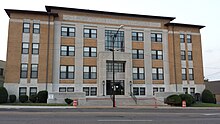
Pope County Courthouse
|
|
 Location in the U.S. state of Arkansas |
|
 Arkansas's location in the U.S. |
|
| Founded | November 2, 1829 |
| Named for | John Pope |
| Seat | Russellville |
| Largest city | Russellville |
| Area | |
| • Total | 831 sq mi (2,152 km2) |
| • Land | 813 sq mi (2,106 km2) |
| • Water | 18 sq mi (47 km2), 2.2% |
| Population (est.) | |
| • (2015) | 63,390 |
| • Density | 76/sq mi (29/km²) |
| Congressional district | 3rd |
| Time zone | Central: UTC-6/-5 |
| Website | www |
Pope County is a county located in the U.S. state of Arkansas. As of the 2010 census, the population was 61,754. The county seat is Russellville. The county was formed on November 2, 1829, from a portion of Crawford County and named for John Pope, the third governor of the Arkansas Territory. It is an alcohol prohibition or dry county.
Pope County is part of the Russellville, AR Micropolitan Statistical Area.
A large Democratic majority was ardently split into a "town or country" dichotomy at the local level. Further, the county was split between Union and Confederate sympathizers, with deep grudges being held by both sides for grievances committed during the opposite's rule during the war. After the war, Republicans controlled local government and the Democrats controlled the county economy. The political situation and cultural differences kept tensions high between the groups, occasionally resulting in violence. The most violent episode came to be known as the Pope County Militia War, a six-month drama involving robbery, plundering and murder. The state-controlled militia eventually arrived to enforce martial law in the county, making the local Democrats who were providing armed resistance to Clayton's Republican army heroes to Confederate sympathizers around the state.
According to the U.S. Census Bureau, the county has a total area of 831 square miles (2,150 km2), of which 813 square miles (2,110 km2) is land and 18 square miles (47 km2) (2.2%) is water.
As of the 2000 United States Census, there were 54,469 people, 20,701 households, and 15,008 families residing in the county. The population density was 67 people per square mile (26/km²). There were 22,851 housing units at an average density of 28 per square mile (11/km²). The racial makeup of the county was 93.73% White, 2.61% Black or African American, 0.68% Native American, 0.64% Asian, 0.03% Pacific Islander, 0.93% from other races, and 1.39% from two or more races. 2.06% of the population were Hispanic or Latino of any race.
...
Wikipedia
