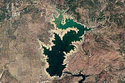
Lake Buchanan (Texas)
| Lake Buchanan (Texas) | |
|---|---|

Landsat 5 image of Lake Buchanan in October 2011
|
|
| Location | Burnet / Llano counties, Texas, USA |
| Coordinates | 30°45.11′N 98°25.12′W / 30.75183°N 98.41867°WCoordinates: 30°45.11′N 98°25.12′W / 30.75183°N 98.41867°W |
| Type | Hydroelectric reservoir |
| Primary inflows | Colorado River |
| Primary outflows | Colorado River |
| Managing agency | Lower Colorado River Authority |
| First flooded | 1939 |
| Surface area | 22,333 acres (34.9 sq mi; 90.4 km2) |
| Max. depth | 132 ft (40 m) |
| Water volume | 875,566 acre·ft (1.079995 km3) |
| Surface elevation | 1,020 ft (310 m) |
Lake Buchanan (/ˈbʌkænən/) was formed by the construction of Buchanan Dam by the Lower Colorado River Authority to provide a water supply for the region and to provide hydroelectric power. Buchanan Dam, a structure over 2 mi (3.2 km) in length, was completed in 1939. Lake Buchanan was the first of the Texas Highland Lakes to be formed, and with 22,333 acres (34.9 sq mi; 90.4 km2) of surface water, it is also the largest. The surface of the lake includes area in both Burnet and Llano Counties. The lake is west of the city of Burnet, Texas.
The other reservoirs on the Colorado River are Inks Lake, Lake LBJ, Lake Marble Falls, Lake Travis, Lake Austin, and Lady Bird Lake.
The lake is named for Representative James P. Buchanan (1867–1937), who is credited with securing the funding to build the lake and dam.
Lake Buchanan was artificially created upon the completion of the adjacent Buchanan Dam in 1938. Work on the dam itself began in April 1931, but was suspended a year later. Work resumed in 1935, with the dam completed three years later. However, deliberate impounding of the reservoir began in May 1937. Initially, the dam and resulting reservoir project was known as Hamilton Dam and Reservoir, but its name was changed to honor Texas State Representative James P. Buchanan upon the completion of the project; Buchanan had been responsible for securing the funding for the project. The flooding of the lake forced the community of Bluffton to relocate 5 mi (8.0 km) westward. The abandoned community was soon inundated; however, a drought in 2011 caused Lake Buchanan's water level to drop significantly, exposing the remains of the town.
...
Wikipedia
