Lake Barcroft, Virginia
| Lake Barcroft, Virginia | |
|---|---|
| Census-designated place | |

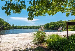
View over Lake Barcroft from Beach 4
|
|
 Location of Lake Barcroft in Fairfax County, Virginia |
|
| Location of Lake Barcroft in Fairfax County, Virginia | |
| Coordinates: 38°51′5″N 77°9′20″W / 38.85139°N 77.15556°WCoordinates: 38°51′5″N 77°9′20″W / 38.85139°N 77.15556°W | |
| Country | United States |
| State | Virginia |
| County | Fairfax |
| Area | |
| • Total | 2.7 sq mi (6.9 km2) |
| • Land | 2.4 sq mi (6.3 km2) |
| • Water | 0.2 sq mi (0.6 km2) |
| Elevation | 262 ft (80 m) |
| Population (2010) | |
| • Total | 9,558 |
| • Density | 3,918/sq mi (1,512.8/km2) |
| Time zone | Eastern (EST) (UTC-5) |
| • Summer (DST) | EDT (UTC-4) |
| FIPS code | 51-43352 |
| GNIS feature ID | 1492515 |
Lake Barcroft is a census-designated place (CDP) in Fairfax County, Virginia, United States. The population was 9,558 at the 2010 census. It is also the name of the privately owned lake—part of the Cameron Run Watershed—around which this population is located. The lake is named for Dr. John W. Barcroft, who owned and operated a mill on Holmes Run during the mid-19th century.
In 1913, the Alexandria Water Company began construction of the Lake Barcroft Dam to create a drinking water reservoir for the city of Alexandria. Construction of the dam was completed in 1915, putting a 620 million-gallon reservoir into service. In 1942, the company installed 24 gates at the top of the dam to raise the spillway elevation five feet, increasing the reservoir size to 800 million gallons.
In 1949, the City of Alexandria began to draw its drinking water from the Occoquan Reservoir. A year later, Colonel Joseph Barger and Associates purchased the reservoir, dam, and 680 adjacent acres of land for $1 million from the Alexandria Water Company. A year later, Barger and Associates began developing the 680 acres (2.8 km2) into a residential community. During the early 1950s, residents formed a homeowners association called the Lake Barcroft Community Association (LABARCA). In 1970, community residents purchased the lake, dam, and common grounds for $300,000, and established the Barcroft Lake Management Association (BARLAMA).
In 1972, Hurricane Agnes passed over the area. The hurricane caused so much rain that the lake level rose above the top of the dam by 3 feet (0.91 m). This resulted in the lake overflowing, and eroding the western, earthen shoulder of the dam. The rush of water deepened the washout, but the slow erosion protected downstream interests from the wall of water that would have resulted from a total dam collapse. In order to restore the dam and lake, residents voted to establish the Lake Barcroft Watershed Improvement District (LBWID) in order to set up a taxing authority to fund repairs. The LBWID is a quasi-governmental entity headed by three state-appointed trustees who are residents of Lake Barcroft. The lake was dry for two years during the early 1970s while the damaged dam was rebuilt. A new gate improved the operation of the dam and is now fully automatic. The dam meets all Commonwealth dam safety requirements.
...
Wikipedia


