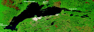
Lake Athabaska
| Lake Athabasca | |
|---|---|

Ice breakup on Lake Athabasca (June 9, 2002)
|
|

Lake Athabasca (August 24, 2002)
|
|
| Location | Division No. 18, Saskatchewan / Wood Buffalo, Alberta |
| Coordinates | 59°16′N 109°27′W / 59.267°N 109.450°WCoordinates: 59°16′N 109°27′W / 59.267°N 109.450°W |
| Primary inflows | Peace River, which backs up through Rivière des Rochers during flooding, Athabasca River, William River, MacFarlane River, Colin River, Fond du Lac River, |
| Primary outflows | Rivière des Rochers that meets with the Peace to form the Slave |
| Catchment area | 274,540 km2 (106,000 sq mi) |
| Basin countries | Canada |
| Max. length | 283 km (176 mi) |
| Max. width | 50 km (31 mi) |
| Surface area | 7,850 km2 (3,030 sq mi) |
| Max. depth | 124 m (407 ft) |
| Shore length1 | ~1,900 km (1,200 mi) |
| Surface elevation | 213 m (699 ft) |
| Settlements | Fort Chipewyan, Uranium City, Camsell Portage, Fond du Lac |
| References | |
| 1 Shore length is not a well-defined measure. | |
Lake Athabasca (/ˌæθəˈbæskə/; French: lac Athabasca; from Woods Cree: aðapaskāw, "[where] there are plants one after another") is located in the northwest corner of Saskatchewan and the northeast corner of Alberta between 58° and 60° N. The lake is 26% in Alberta and 74% in Saskatchewan.
The name in the Dene language originally referred only to the large delta formed by the confluence of the Athabasca River at the southwest corner of the lake. Prior to 1789, Sir Alexander Mackenzie explored the lake. In 1791, Philip Turnor, cartographer for the Hudson’s Bay Company, wrote in his journal, "low swampy ground on the South side with a few willows growing upon it, from which the Lake in general takes its name Athapison in the Southern Cree tongue which signifies open country such as lakes with willows and grass growing about them". Peter Fidler originally recorded the name for the river in 1790 as the Great Arabuska. By 1801, the name had gained a closer spelling to the current name—Athapaskow Lake. By 1820, George Simpson referred to both the lake and the river as "Athabasca".
The lake covers 7,850 km2 (3,030 sq mi), is 283 km (176 mi) long, has a maximum width of 50 km (31 mi), and a maximum depth of 124 m (407 ft), and holds 204 km3 (49 cu mi) of water, making it the largest and deepest lake in both Alberta and Saskatchewan, and the eighth largest in Canada. Water flows northward from the lake via the Slave River and Mackenzie River systems, eventually reaching the Arctic Ocean.
...
Wikipedia
