Peace River
| Peace River | |
| Rivière de la Paix | |
|
Peace River at Peace River, Alberta
|
|
| Name origin: Peace Point, Alberta, where a treaty marking the river as the boundary between Beaver and Cree was signed in 1781 | |
| Country | Canada |
|---|---|
| Province | British Columbia, Alberta |
| Part of | Mackenzie River watershed |
| Tributaries | |
| - left | Finlay River, Halfway River, Beatton River, Clear River (Alberta), Ponton River |
| - right | Parsnip River, Pine River, Kiskatinaw River, Pouce Coupé River, Smoky River, Wabasca River, Mikkwa River |
| Cities | Fort Saint John, British Columbia, Peace River, Alberta |
| Primary source | Finlay River |
| - location | Thutade Lake, British Columbia |
| - elevation | 1,140 m (3,740 ft) |
| - coordinates | 57°04′29″N 126°53′36″W / 57.07472°N 126.89333°W |
| Secondary source | Parsnip River |
| - location | Near Mount Barton, British Columbia |
| - elevation | 5,630 m (18,471 ft) |
| - coordinates | 54°30′02″N 121°26′26″W / 54.50056°N 121.44056°W |
| Source confluence | Williston Lake (Former confluence of Peace and Parsnip Rivers, now submerged underneath Williston Lake) |
| - elevation | 748 m (2,454 ft) (Elevation of Williston Lake) |
| - coordinates | 55°59′21″N 123°50′08″W / 55.98917°N 123.83556°W |
| Mouth | Slave River |
| - location | Confluence of Peace with Athabasca River, Alberta |
| - coordinates | 59°00′01″N 111°24′38″W / 59.00028°N 111.41056°WCoordinates: 59°00′01″N 111°24′38″W / 59.00028°N 111.41056°W |
| Length | 1,923 km (1,195 mi) |
| Basin | 306,000 km2 (118,147 sq mi) |
| Discharge | for Peace Point, Alberta |
| - average | 2,110 m3/s (74,514 cu ft/s) |
| - max | 9,790 m3/s (345,731 cu ft/s) |
| - min | 344 m3/s (12,148 cu ft/s) |
|
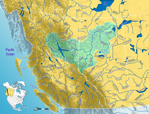
Map of the Peace River watershed in western Canada
|
|
The Peace River (French: rivière de la Paix) is a river in Canada that originates in the Rocky Mountains of northern British Columbia and flows to the northeast through northern Alberta. The Peace River flows into the Slave River, a tributary of the Mackenzie River. The Mackenzie is the 12th longest river in the world, preceded by the Mekong and followed by the Niger River. The Finlay River, the main headwater of the Peace River, is regarded as the ultimate source of the Mackenzie River.
The regions along the river are the traditional home of the Danezaa people, called the Beaver by the Europeans. The fur trader Peter Pond is believed to have visited the river in 1785. In 1788 Charles Boyer of the North West Company established a fur trading post at the river's junction with the Boyer River.
In 1792 and 1793, the explorer Alexander Mackenzie travelled up the river to the Continental Divide. Mackenzie referred to the river as Unjegah, from a native word meaning "large river".
The decades of hostilities between the Danezaa and the Cree, (in which the Cree dominated the Danezaa), ended in 1781 when a smallpox epidemic decimated the Cree. The Treaty of the Peace was celebrated by the smoking of a ceremonial pipe. The treaty made the Peace River a border, with the Danezaa to the North and the Cree to the South.
...
Wikipedia


