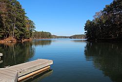
Lake Allatoona
| Lake Allatoona | |
|---|---|

Seen from Red Top Mountain State Park
|
|
| Location | Georgia, United States |
| Coordinates | 34°8′18″N 84°38′38″W / 34.13833°N 84.64389°WCoordinates: 34°8′18″N 84°38′38″W / 34.13833°N 84.64389°W |
| Type | reservoir |
| Primary inflows | Etowah River, Allatoona Creek, Little River, Noonday Creek |
| Primary outflows | Etowah River |
| Basin countries | United States |
| Surface area | 12,010 acres (48.6 km2) |
| Max. depth | 44.196 metres (145.00 ft) |
| Water volume | 367,500 acre·ft (0.4533 km3) |
| Surface elevation | 840 feet (260 m) |
| Islands | Seven Islands |
| Settlements | Acworth |
Lake Allatoona (rarely called Allatoona Lake, its government name) is a U.S. Army Corps of Engineers reservoir in Georgia, located in northwestern metro Atlanta. The lake is mostly in southwestern Cherokee County, but a significant part is in southeastern Bartow County, and a small part in Cobb County near Acworth. Cartersville is the nearest large town to Allatoona Dam. Red Top Mountain State Park is located on its shores, on the peninsula between the Etowah and Allatoona arms of the lake. Most of the north side of the lake remains protected from land development because of its isolated location, mostly blocked by the lake.
Allatoona serves seven authorized purposes:
There are several private marinas and public boat ramps.
Allatoona also supplies much of the drinking water for the three counties it is in. The lake is supplied mostly by the Etowah River, and its major tributary the Little River (which joins the lake at Bell's Ferry), and in turn Noonday Creek. The other major arm of the lake is Allatoona Creek, extending down to Acworth, where pre-existing Lake Acworth now empties directly into Allatoona at Lake Acworth Drive (Georgia 92). Other significant streams include Kellogg Creek and Rose Creek.
...
Wikipedia
