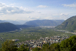
Laives
| Laives | |
|---|---|
| Comune | |
| Comune di Laives Gemeinde Leifers |
|

Panorama of Laives.
|
|
| Location of Laives in Italy | |
| Coordinates: 46°26′N 11°20′E / 46.433°N 11.333°ECoordinates: 46°26′N 11°20′E / 46.433°N 11.333°E | |
| Country | Italy |
| Region | Trentino-Alto Adige/Südtirol |
| Province / Metropolitan city | South Tyrol (BZ) |
| Frazioni | Pineta (Steinmannwald), La Costa (Seit), San Giacomo (St. Jakob) |
| Government | |
| • Mayor | Christian Bianchi |
| Area | |
| • Total | 24.3 km2 (9.4 sq mi) |
| Elevation | 258 m (846 ft) |
| Population (Nov. 2010) | |
| • Total | 17,168 |
| • Density | 710/km2 (1,800/sq mi) |
| Demonym(s) | Italian: Laivesotti German: Leiferer |
| Time zone | CET (UTC+1) |
| • Summer (DST) | CEST (UTC+2) |
| Postal code | 39055 |
| Dialing code | 0471 |
| Website | Official website |
Laives (Italian pronunciation: [ˈlaives]; German: Leifers [ˈlaɪ̯fɐs]) is a town and a comune (municipality) in South Tyrol in northern Italy, located about 8 kilometres (5 mi) south of the city of Bolzano. It is one of only five mainly Italian speaking municipalities in South Tyrol, and the fourth largest municipality in the province.
As of November 30, 2010, it had a population of 17,168 and an area of 24.3 square kilometres (9.4 sq mi).
The municipality contains the frazioni (subdivisions) Pineta (Steinmannwald), La Costa (Seit) and San Giacomo (St. Jakob)
The emblem consists of an argent pile, with concave sides on azure and a chapel on a mountain of gules. The sign, similar to that of the Counts of Lichtenstein who lived in the castle on Mount Köfele, represents the church of Peterköfele. The emblem was adopted in 1970.
According to the 2011 census, 71.50% of the population speak Italian, 27.99% German and 0.51% Ladin as first language.
...
Wikipedia

