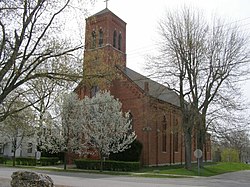
Lagro, Indiana
| Lagro, Indiana | |
|---|---|
| Town | |

St. Patricks Catholic Church, founded in 1836 on the Wabash & Erie Canal
|
|
 Location in the state of Indiana |
|
| Coordinates: 40°50′16″N 85°43′40″W / 40.83778°N 85.72778°WCoordinates: 40°50′16″N 85°43′40″W / 40.83778°N 85.72778°W | |
| Country | United States |
| State | Indiana |
| County | Wabash |
| Township | Lagro |
| Area | |
| • Total | 0.60 sq mi (1.55 km2) |
| • Land | 0.59 sq mi (1.53 km2) |
| • Water | 0.01 sq mi (0.03 km2) |
| Elevation | 705 ft (215 m) |
| Population (2010) | |
| • Total | 415 |
| • Estimate (2012) | 409 |
| • Density | 703.4/sq mi (271.6/km2) |
| Time zone | EST (UTC-5) |
| • Summer (DST) | EST (UTC-5) |
| ZIP code | 46941 |
| Area code(s) | 260 |
| FIPS code | 18-40896 |
| GNIS feature ID | 449680 |
Lagro is a town in Lagro Township, Wabash County, in the U.S. state of Indiana. The population was 415 at the 2010 census.
The community was named after Le Gris, a Miami Chief. The Lagro post office has been in operation since 1893.
St. Patrick's Roman Catholic Church was listed on the National Register of Historic Places in 1999.
Lagro is located at 40°50′16″N 85°43′40″W / 40.83778°N 85.72778°W (40.837758, -85.727721), along the Wabash River opposite the mouth of the Salamonie River.
According to the 2010 census, Lagro has a total area of 0.6 square miles (1.55 km2), of which 0.59 square miles (1.53 km2) (or 98.33%) is land and 0.01 square miles (0.03 km2) (or 1.67%) is water.
As of the census of 2010, there were 415 people, 156 households, and 110 families residing in the town. The population density was 703.4 inhabitants per square mile (271.6/km2). There were 184 housing units at an average density of 311.9 per square mile (120.4/km2). The racial makeup of the town was 96.9% White, 1.7% Native American, 0.5% Asian, and 1.0% from two or more races.
...
Wikipedia
