Lafayette Township, New Jersey
| Lafayette Township, New Jersey | |
|---|---|
| Township | |
| Township of Lafayette | |

Lafayette Mill
|
|
 Map of Lafayette Township in Sussex County. Inset: Location of Sussex County highlighted in the State of New Jersey. |
|
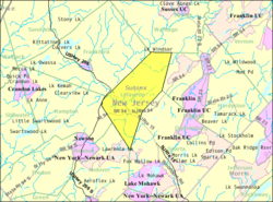
 Census Bureau map of Lafayette Township, New Jersey |
|
| Coordinates: 41°06′47″N 74°40′32″W / 41.113067°N 74.675675°WCoordinates: 41°06′47″N 74°40′32″W / 41.113067°N 74.675675°W | |
| Country |
|
| State |
|
| County | Sussex |
| Incorporated | April 14, 1845 |
| Named for | Gilbert du Motier, Marquis de Lafayette |
| Government | |
| • Type | Township |
| • Body | Township Committee |
| • Mayor | Gregory Corcoran (R, term ends December 31, 2017) |
| • Clerk | AnnaRose Fedish |
| Area | |
| • Total | 18.049 sq mi (46.748 km2) |
| • Land | 17.962 sq mi (46.522 km2) |
| • Water | 0.087 sq mi (0.226 km2) 0.48% |
| Area rank | 157th of 566 in state 13th of 24 in county |
| Elevation | 535 ft (163 m) |
| Population (2010 Census) | |
| • Total | 2,538 |
| • Estimate (2015) | 2,439 |
| • Rank | 470th of 566 in state 18th of 24 in county |
| • Density | 141.3/sq mi (54.6/km2) |
| • Density rank | 528th of 566 in state 21st of 24 in county |
| Time zone | Eastern (EST) (UTC-5) |
| • Summer (DST) | Eastern (EDT) (UTC-4) |
| ZIP code | 07848 |
| Area code(s) | 973 |
| FIPS code | 3403737440 |
| GNIS feature ID | 0882260 |
| Website | www |
Lafayette Township is a township located in the Skylands Region of Sussex County, New Jersey, United States. As of the 2010 United States Census, the township's population was 2,538, reflecting an increase of 238 (+10.3%) from the 2,300 counted in the 2000 Census, which had in turn increased by 398 (+20.9%) from the 1,902 counted in the 1990 Census.
Lafayette was formed as a Township based on an Act of the New Jersey Legislature on April 14, 1845, from part of Frankford Township and Newton Township (the latter now dissolved), based on the results of a referendum held that same day. The township was the first in the country to be named for Gilbert du Motier, Marquis de Lafayette, the French general and statesman who served in the Continental Army during the American Revolutionary War.
The township is crossed by Route 15 and Route 94.
According to the United States Census Bureau, the township had a total area of 18.049 square miles (46.748 km2), including 17.962 square miles (46.522 km2) of land and 0.087 square miles (0.226 km2) of water (0.48%).
Unincorporated communities, localities and place names located partially or completely within the township include Branchville Junction, Harmonyvale, Hopkins Corner, Warbasse and Warbasse Junction.
...
Wikipedia
