La Pacana
| Pacana Caldera | |
|---|---|

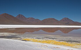
Viewing from inside the caldera towards the western margin
|
|
| Highest point | |
| Elevation | 4,500 m (14,800 ft) |
| Listing | List of volcanoes in Chile |
| Coordinates | 23°10′S 67°25′W / 23.167°S 67.417°WCoordinates: 23°10′S 67°25′W / 23.167°S 67.417°W |
| Geography | |
|
Northern Chile
|
|
| Geology | |
| Mountain type | Caldera |
| Volcanic arc/belt | Altiplano–Puna volcanic complex |
| Last eruption | 2 mya |
La Pacana is a Miocene age caldera in northern Chile's Antofagasta Region. Part of the Central Volcanic Zone of the Andes, it is part of the Altiplano-Puna volcanic complex, a major caldera and silicic ignimbrite volcanic field. This volcanic field is located in remote regions at the Zapaleri tripoint between Chile, Bolivia and Argentina.
La Pacana along with other regional volcanoes was formed by the subduction of the Nazca Plate beneath the South American Plate in the Peru-Chile Trench. La Pacana is situated in a basement formed by various Paleozoic formations and Tertiary ignimbrites and volcanoes. Several major faults cross the region at La Pacana and have influenced its volcanic activity.
La Pacana is a supervolcano and is responsible for the eruption of the giant Atana ignimbrite, which reaches a volume of 2,451–3,500 cubic kilometres (588–840 cu mi) and constitutes the fifth-largest explosive eruption known. The Atana ignimbrite was erupted 3.8 ± 0.1 and 4.2 ± 0.1 million years ago, almost simultaneously with the much smaller (volume of 180 cubic kilometres (43 cu mi)) Toconao ignimbrite. Other ignimbrites were erupted by La Pacana before (the Pujsa ignimbrite) and after (the Filo Delgado and Pampa Chamaca/Talabre ignimbrites) the Atana/Toconao ignimbrites.
...
Wikipedia

