La Chapelle-d'Angillon
| La Chapelle-d’Angillon | ||
|---|---|---|

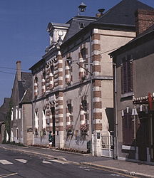
The town hall and school in La Chapelle-d'Angillon
|
||
|
||
| Coordinates: 47°21′51″N 2°26′02″E / 47.3642°N 2.4339°ECoordinates: 47°21′51″N 2°26′02″E / 47.3642°N 2.4339°E | ||
| Country | France | |
| Region | Centre-Val de Loire | |
| Department | Cher | |
| Arrondissement | Vierzon | |
| Canton | Aubigny-sur-Nère | |
| Intercommunality | Sauldre et Sologne | |
| Government | ||
| • Mayor (2008–2015) | Guy Amelot | |
| Area1 | 10.17 km2 (3.93 sq mi) | |
| Population (2008)2 | 665 | |
| • Density | 65/km2 (170/sq mi) | |
| Time zone | CET (UTC+1) | |
| • Summer (DST) | CEST (UTC+2) | |
| INSEE/Postal code | 18047 /18380 | |
| Elevation | 183–283 m (600–928 ft) (avg. 192 m or 630 ft) |
|
|
1 French Land Register data, which excludes lakes, ponds, glaciers > 1 km² (0.386 sq mi or 247 acres) and river estuaries. 2Population without double counting: residents of multiple communes (e.g., students and military personnel) only counted once. |
||
1 French Land Register data, which excludes lakes, ponds, glaciers > 1 km² (0.386 sq mi or 247 acres) and river estuaries.
La Chapelle-d’Angillon is a commune in the Cher department in the Centre region of France.
A village of lakes, forestry and farming situated in the valley of the river Sauldre, some 20 miles (32 km) north of Bourges at the junction of the D12, D940 and the D926 roads.
Realization of a sculpture by French artist from Albens Jean-Louis Berthod, in 2014. The board is a tribute to the book of Alain-Fournier, "Meaulnes the Great", but also to the missing persons of the Great War. Insite the board, we can admirate the "Chateau of La Chapelle-d'Angillon".
...
Wikipedia


