La Bastide-l'Évêque
| La Bastide-l'Évêque | ||
|---|---|---|

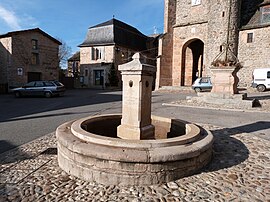
The Fountain in the main Square
|
||
|
||
| Coordinates: 44°20′29″N 2°08′07″E / 44.3414°N 2.1353°ECoordinates: 44°20′29″N 2°08′07″E / 44.3414°N 2.1353°E | ||
| Country | France | |
| Region | Occitanie | |
| Department | Aveyron | |
| Arrondissement | Villefranche-de-Rouergue | |
| Canton | Aveyron et Tarn | |
| Government | ||
| • Mayor (2008–2020) | Jean-Eudes Le Meignon | |
| Area1 | 44.16 km2 (17.05 sq mi) | |
| Population (2010)2 | 820 | |
| • Density | 19/km2 (48/sq mi) | |
| Time zone | CET (UTC+1) | |
| • Summer (DST) | CEST (UTC+2) | |
| INSEE/Postal code | 12021 /12200 | |
| Elevation | 280–713 m (919–2,339 ft) (avg. 470 m or 1,540 ft) |
|
|
1 French Land Register data, which excludes lakes, ponds, glaciers > 1 km² (0.386 sq mi or 247 acres) and river estuaries. 2Population without double counting: residents of multiple communes (e.g., students and military personnel) only counted once. |
||
1 French Land Register data, which excludes lakes, ponds, glaciers > 1 km² (0.386 sq mi or 247 acres) and river estuaries.
La Bastide-l'Évêque is a former commune in the Aveyron department in the Occitanie region of southern France. On 1 January 2016, it was merged into the new commune of Le Bas-Ségala.
The inhabitants of the commune are known as Episcopois or Episcopoises.
La Bastide-l'Évêque is located some 5 km east of Villefranche-de-Rouergue and 20 km south by south-west of Decazeville. Access to the commune is by the D911 which comes from Villefranche-de-Rouergue passing along the south-western border of the commune and crossing the narrow neck in the south as it goes east to Rieupeyroux. Access to the village is by the D69 which branches from the D911 on the western commune border and passes through the village continuing east to rejoin the D911 on the eastern border. The D269 goes north from the village then turns west following the northern border and continuing to Villefranche-de-Rouergue. The D905A branches from the D911 in the south of the commune and goes south-east to La Salvetat-Peyralès. Apart from the village the commune has a large number of hamlets:
The commune is mostly farmland interspersed with a few forests.
The Aveyron river forms most of the northern border as it flows west to eventually join the Tarn at Meauzac. The Lézert flows north through the commune to join the Aveyron on the northern border. The Verlanson also flows north joining the Lézert south of the village. The Ruisseau de Pouzoulet rises near Les Gazanes and also flows north to join the Aveyron. The Ruisseau de Caral rises in the east of the commune and flows north to join the Aveyron.
A list of online mapping systems can be displayed by clicking on the coordinates (latitude and longitude) in the top right hand corner of this article.
...
Wikipedia


