L'Île-d'Yeu
| L'Île-d'Yeu | ||
|---|---|---|
| Commune | ||

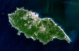
A satellite image of the island
|
||
|
||
| Coordinates: 46°43′30″N 2°20′49″W / 46.725°N 2.347°WCoordinates: 46°43′30″N 2°20′49″W / 46.725°N 2.347°W | ||
| Country | France | |
| Region | Pays de la Loire | |
| Department | Vendée | |
| Arrondissement | Les Sables-d'Olonne | |
| Canton | L'Île-d'Yeu | |
| Area1 | 23.32 km2 (9.00 sq mi) | |
| Population (2006)2 | 5,001 | |
| • Density | 210/km2 (560/sq mi) | |
| Time zone | CET (UTC+1) | |
| • Summer (DST) | CEST (UTC+2) | |
| INSEE/Postal code | 85113 /85350 | |
| Elevation | 0–32 m (0–105 ft) (avg. 20 m or 66 ft) |
|
|
1 French Land Register data, which excludes lakes, ponds, glaciers > 1 km² (0.386 sq mi or 247 acres) and river estuaries. 2Population without double counting: residents of multiple communes (e.g., students and military personnel) only counted once. |
||
1 French Land Register data, which excludes lakes, ponds, glaciers > 1 km² (0.386 sq mi or 247 acres) and river estuaries.
Île d'Yeu (French pronunciation: [il djø]) is an island and commune just off the Vendée coast of western France. The island's two harbours, Port-Joinville in the north and Port de la Meule, located in a rocky inlet of the southern granite coast, are famous for the fishing of tuna and lobster.
Administratively, the commune of L'Île-d'Yeu (with that spelling) forms part of the Vendée department and the Pays de la Loire region of France.
The island is reached by ferry from Fromentine or Saint-Gilles-Croix-de-Vie. Air transportation is available at Île d'Yeu Aerodrome (IATA: IDY, ICAO: LFEY), with commercial service from Nantes Airport.
Neolithic markings in the native stone and an unusual concentration of megalithic dolmens and menhirs attest to the island's early sanctity. Irish monks from Bangor, County Down, dedicated their monastery on the Île d'Yeu to Hilaire; Saint Amand, from Poitou received early training there, but it was destroyed by Viking raiders in the ninth century.
...
Wikipedia


