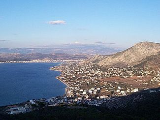
Kynosoura
|
Salamis Σαλαμίνα |
|
|---|---|
|
View of Salamina
|
|
| Coordinates: 37°56′N 23°30′E / 37.933°N 23.500°ECoordinates: 37°56′N 23°30′E / 37.933°N 23.500°E | |
| Country | Greece |
| Administrative region | Attica |
| Regional unit | Islands |
| Government | |
| • Mayor | Ioannis Tsavaris (Ind.) |
| Area | |
| • Municipality | 96.16 km2 (37.13 sq mi) |
| Population (2011) | |
| • Municipality | 39,283 |
| • Municipality density | 410/km2 (1,100/sq mi) |
| Time zone | EET (UTC+2) |
| • Summer (DST) | EEST (UTC+3) |
| Postal code | 189 xx |
| Area code(s) | 21 |
| Vehicle registration | Y |
| Website | www.salamina.gr |
| {{{footnotes}}} | |
Salamis (/ˈsæləmᵻs/; Greek: Σαλαμίνα Salamína, Ancient and Katharevousa: Σαλαμίς Salamís), is the largest Greek island in the Saronic Gulf, about 1 nautical mile (2 km) off-coast from Piraeus and about 16 kilometres (10 miles) west of Athens. The chief city, Salamina, lies in the west-facing core of the crescent on Salamis Bay, which opens into the Saronic Gulf. On the Eastern side of the island is its main port, Paloukia, in size second in Greece only to Piraeus, the port of Athens.
The traditional etymology of Salamis derives it from the eponymous nymph Salamis, the mother of Cychreus, the legendary first king of the island. A more modern theory considers "Salamis" to come from the root sal 'salt' and -amis 'middle'; thus Salamis would be the place amid salt water. Some scholars connect it to the Semitic root Š-L-M 'health, safety, peace', because of the well-sheltered harbor.
From at least the 13th century until the 19th century, the town, the island, and the bay of Salamis were called Koulouri (Κουλούρι), presumably because it was round like the bread called 'koulouri'. The ancient name was revived in the 19th century. The name Koulouri is still used informally for the town.
...
Wikipedia


