Kuvshinovsky District
| Kuvshinovsky District Кувшиновский район (Russian) |
|
|---|---|
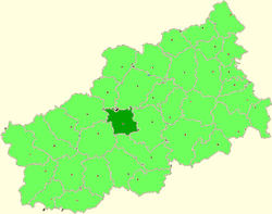
 Location of Kuvshinovsky District in Tver Oblast |
|
| Coordinates: 57°05′48″N 34°24′32″E / 57.09667°N 34.40889°ECoordinates: 57°05′48″N 34°24′32″E / 57.09667°N 34.40889°E | |
|
|
|
| Location | |
| Country | Russia |
| Federal subject | Tver Oblast |
| Administrative structure (as of 2012) | |
| Administrative center | town of Kuvshinovo |
| Administrative divisions: | |
| Urban settlements | 1 |
| Rural settlements | 12 |
| Inhabited localities: | |
| Cities/towns | 1 |
| Rural localities | 165 |
| Municipal structure (as of June 2006) | |
| Municipally incorporated as | Kuvshinovsky Municipal District |
| Municipal divisions: | |
| Urban settlements | 1 |
| Rural settlements | 12 |
| Statistics | |
| Area | 1,874 km2 (724 sq mi) |
| Population (2010 Census) | 15,386 inhabitants |
| • Urban | 65.0% |
| • Rural | 35.0% |
| Density | 8.21/km2 (21.3/sq mi) |
| Time zone | MSK (UTC+03:00) |
| Official website | |
| on | |
Kuvshinovsky District (Russian: Кувши́новский райо́н) is an administrative and municipal district (raion), one of the thirty-six in Tver Oblast, Russia. It is located in the center of the oblast and borders with Vyshnevolotsky District in the north, Torzhoksky District in the east, Staritsky District in the south, Selizharovsky District in the southwest, Ostashkovsky District in the west, and with Firovsky District in the northwest. The area of the district is 1,874 square kilometers (724 sq mi). Its administrative center is the town of Kuvshinovo. Population: 15,386 (2010 Census);17,847 (2002 Census);20,601 (1989 Census). The population of Kuvshinovo accounts for 65.0% of the district's total population.
Kuvshinovsky District list in the southern part of the Valdai Hills, and the divide between the drainage basins of the Atlantic Ocean and the Caspian Sea runs through the district. The northern part of the district belongs to the drainage basin of the Tsna River, a tributary of Lake Mstino in the drainage basin of the Neva and the Baltic Sea. The Tsna itself has its source the district. The rivers in the center and in the south of the district belong to the basin of the Volga. The major part of the district belongs to the basin of the Osuga River, which crosses the district from est to east. The rivers in the southern part of the district drain into the Bolshaya Kosha, which has its source in the district. The Osuga is a right tributary of the Tvertsa, a left tributary of the Volga, whereas the Bolshaya Kosha is a left tributary of the Volga. 76% of the area of the district is occupied by forest.
...
Wikipedia

