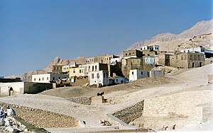
Kurna
| Kurna | |
|---|---|

Village of Qurna
|
|
| Location in Egypt | |
| Coordinates: 25°43′30″N 32°37′15″E / 25.72500°N 32.62083°ECoordinates: 25°43′30″N 32°37′15″E / 25.72500°N 32.62083°E | |
| Country |
|
| Governorate | Luxor Governorate |
| Time zone | EST (UTC+2) |
| • Summer (DST) | +3 (UTC) |
Kurna (also Gourna, Gurna, Qurna, Qurnah or Qurneh) are various spelling for a group of three closely related villages (New Qurna, Qurna and Sheikh ‘Adb el-Qurna) located on the West Bank of the River Nile opposite the modern city of Luxor in Egypt near the Theban Hills.
New Qurna was designed and built in the late 1940s and early 1950s by Egyptian architect Hassan Fathy to house people living in Qurna which is now uninhabited. New Qurna was added to the 2010 World Monuments Watch List of Most Endangered Sites to bring attention to the site's importance to modern town planning and vernacular architecture due to the loss of much of the original form of the village since it was built.
The name Kurna signifies "a promontory" or "a point of a mountain".
Gourna is first mentioned by Protais and Charles François d'Orléans, two Capuchin missionary brothers travelling in Upper Egypt in 1668. Protais’ writing about their travel was published by Melchisédech Thévenot (Relations de divers voyages curieux, 1670s-1696 editions) and Johann Michael Vansleb (The Present State of Egypt, 1678).
References to Qurna, Gurna, Kournou, Gourna, El-Ckoor’neh, Gourne, el Abouab, El-Goor’neh or many other variants in pre-1940s literature refers to a spread out urban sprawl of housings stretching from approximately the Ramesseum (Mortuary Temple of Ramesses II) to the Mortuary Temple of Seti I on the east side of the Theban Hills, including the current place names of Sheikh ‘Adb el-Qurna, el-Assasif, el-Khokha, Dra ’Abu el-Nage’ and Qurna.
...
Wikipedia

