Kula (Serbia)
|
Kula Кула |
||
|---|---|---|
| Town and municipality | ||

Town center of Kula
|
||
|
||
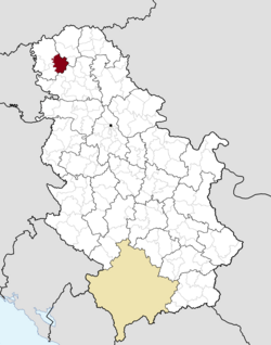
 Location of the municipality of Kula within Serbia |
||
| Coordinates: 45°36′N 19°32′E / 45.600°N 19.533°ECoordinates: 45°36′N 19°32′E / 45.600°N 19.533°E | ||
| Country |
|
|
| Province | Vojvodina | |
| District | West Bačka | |
| Settlements | 7 | |
| Government | ||
| • Mayor | Perica Videkanić | |
| Area | ||
| • Municipality | 481 km2 (186 sq mi) | |
| Population (2011 census) | ||
| • Town | 17,866 | |
| • Municipality | 43,101 | |
| Time zone | CET (UTC+1) | |
| • Summer (DST) | CEST (UTC+2) | |
| Postal code | 25230 | |
| Area code | +381 25 | |
| Car plates | SO | |
| Website | www |
|
Kula (Serbian Cyrillic: Кула) is a town and municipality located in the West Bačka District of the autonomous province of Vojvodina, Serbia. The town has a population of 17,866, while the municipality has a population of 43,101.
In Serbian, the town is known as Kula (Кула); in Rusyn as Кула, in Hungarian as Kúla, in Croatian as Kula, in German as Kula or Wolfsburg, and in Turkish as Kula.
The name Kula means "tower" in Turkish and Serbian. In the 16th-17th century, a tower with Ottoman military garrison existed at this location, hence the name of the town. However it cannot be said for sure whether Ottoman Turks or local Serbs gave this name to the town.
In the middle of the 17th century, during Ottoman administration, two settlements with this name were mentioned - Gornja Kula and Donja Kula. These settlements were part of the Ottoman Sanjak of Segedin and were populated by ethnic Serbs. From the end of the 17th century, the region was under administration of the Habsburg Monarchy and two settlements were mentioned as Mala Kula and Velika Kula and were unpopulated. In 1714, there was a record about single settlement named Kula that had 14 houses. In 1733, the population of the settlement numbered 251 houses and its inhabitants were Serbs. Hungarians started to settle there in 1740 and Germans in 1780-1785.
...
Wikipedia

