Krotoszyn
| Krotoszyn | ||
|---|---|---|

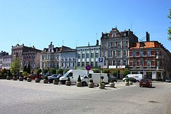
Market Square
|
||
|
||
| Coordinates: 51°41′N 17°26′E / 51.683°N 17.433°E | ||
| Country |
|
|
| Voivodeship | Greater Poland | |
| County | Krotoszyn County | |
| Gmina | Gmina Krotoszyn | |
| Established | 15th century | |
| Town rights | 1415 | |
| Government | ||
| • Mayor | Franciszek Marszalek | |
| Area | ||
| • Total | 22.55 km2 (8.71 sq mi) | |
| Highest elevation | 140 m (460 ft) | |
| Lowest elevation | 130 m (430 ft) | |
| Population (2006) | ||
| • Total | 29,421 | |
| • Density | 1,300/km2 (3,400/sq mi) | |
| Time zone | CET (UTC+1) | |
| • Summer (DST) | CEST (UTC+2) | |
| Postal code | 63–700 to 63–710 | |
| Area code(s) | +48 62 | |
| Car plates | PKR | |
| Climate | Cfb | |
| Website | http://www.krotoszyn.pl | |
Krotoszyn [krɔˈtɔʂɨn] (German: Krotoschin, Yiddish: קארטשין Kortshin) is a town in central Poland with 30,010 inhabitants as of 2005[update]. It has been part of the Greater Poland Voivodeship since 1999; it was within Kalisz Voivodeship from 1975 to 1998.
Historically part of the Kingdom of Poland, during the German rule in the 19th century after the Partitions of Poland, the town was located in the Prussian province of Posen. The dominant trade is in grain and seeds, and the headquarters of the Polish branch of Mahle GmbH is located there. The castle of Krotoszyn was the centre of a mediatized principality formed in 1819 out of the holdings of the Prussian crown and granted to the prince of Thurn und Taxis in compensation for his relinquishing control over the Prussian postal system.
Krotoszyn is twinned with:
Coordinates: 51°41′N 17°26′E / 51.683°N 17.433°E
...
Wikipedia


